LAND OWNERSHIP PATTERNS AND EARLY DEVELOPMENT IN MIDDLE PLANTATION: REPORT OF ARCHIVAL RESEARCH
Colonial Williamsburg Foundation Library Research Report Series - 1724
Colonial Williamsburg Foundation Library
Williamsburg, Virginia
2010
LAND OWNERSHIP PATTERNS AND EARLY DEVELOPMENT IN MIDDLE PLANTATION: REPORT OF ARCHIVAL RESEARCH
COLONIAL WILLIAMSBURG FOUNDATION
Department of Archaeological Research
February 2000
Re-issued
June 2004
Table of Contents
| Page | |
| INTRODUCTION | 1 |
| THE ORIGIN OF THE MIDDLE PLANTATION | 1 |
| Construction of the First and Second Palisade | 1 |
| The Maturation of Community Development | 5 |
| MIDDLE PLANTATION'S FIRST SETTLERS | 6 |
| Dr. John Pott | 6 |
| Lieutenant Richard Popeley | 7 |
| William Davis (Davies) | 8 |
| John Clarke | 8 |
| Robert Higginson | 9 |
| George Read (Reade) | 9 |
| George Lake | 10 |
| George Menefie (Minify) | 11 |
| THE KEMP-LUDWELL HOLDINGS | 12 |
| Richard Kemp | 12 |
| Thomas Hill | 17 |
| Thomas Ludwell | 17 |
| Philip Ludwell I | 18 |
| Thomas Ballard I and Thomas Ballard II | 19 |
| Governor Francis Nicholson | 20 |
| John Young | 21 |
| Cultural Features Potentially Associated the Ballard/College Tract | 22 |
| The Rev. James Blair | 22 |
| Archaeological Features Associated with the Rev. James Blair's Property | 24 |
| THE SAINES/PEALE/WEEKES LANDHOLDINGS | 24 |
| John Saines | 24 |
| Francis Peale | 24 |
| Robert Weekes | 24 |
| Cultural Features Associated with the Saines/Peale/Weekes Tract | 26 |
| THE BRAY HOLDINGS | 26 |
| James Bray I | 26 |
| Angelica Bray (Mrs. James Bray I) | 28 |
| Thomas Bray I (son of James Bray I) | 29 |
| David Bray I (son of James Bray I) | 29 |
| Ann Bray Ingles (daughter of James Bray I) | 30 |
| David Bray II (son of David Bray I) | 31 |
| James Bray II (son of James Bray I) | 32 |
| Thomas Bray II (son of James Bray II) | 32 |
| ii | |
| James Bray III (son of Thomas Bray II) | 34 |
| Elizabeth Bray Johnson (daughter of Thomas Bray II) | 36 |
| Bray Property Associated with the Ballard Family | 37 |
| Cultural Features Associated with the Bray Property | 38 |
| Benjamin Harrison Jr.'s Houses | 38 |
| THE CUSTIS FAMILY HOLDINGS | 39 |
| Daniel Parke (Park) II | 39 |
| John Custis IV | 40 |
| Cultural Features That May Be On the Custis Property | 42 |
| THE PAGE LANDHOLDINGS | 42 |
| Colonel John Page | 42 |
| Francis Page (son of Colonel John and Alice Page) | 49 |
| Elizabeth Page Page (the daughter of Francis Page) | 52 |
| Elizabeth Page Bray (the granddaughter of Francis Page) | 52 |
| Archaeological Features Associated with Francis Page's 168 Acres | 53 |
| Archaeological Features Associated with Colonel John Page's Plantation | 54 |
| Archaeological Features Near the Wythe House | 54 |
| Archaeological Features in Duke of Gloucester Street | 55 |
| Publicly Owned Buildings on the Capitol Grounds | 55 |
| THE DYER FAMILY'S LANDHOLDINGS | 56 |
| William Dyer | 56 |
| Henry Dyer | 56 |
| BIBLIOGRAPHY | 57 |
INTRODUCTION
The reconstruction of land ownership patterns in that portion of Middle Plantation (later, Williamsburg) which originated in James City County is impeded by the loss of that jurisdiction's antebellum court records. However, four seventeenth century plats and a fifth that dates to the eighteenth century, all of which are associated with Rich Neck, provide data that are of critical importance in piecing together the boundaries of contiguous properties. Boundary descriptions included in deeds pertaining to two subsidiary parcels, severed from Rich Neck in 1699 and 1707, also are of immense value, as is a 1960 plat that includes part of Rich Neck's northwesterly boundary line. Patents, York County records, minutes of the colony's assembly, and a broad primary sources have been used throughout the research process, as have reports produced by other scholars. Collectively, all works provide important clues to the configuration of properties and how land ownership patterns evolved over time. This, in turn, enhances our understanding of Middle Plantation's cultural setting.
THE ORIGIN OF THE MIDDLE PLANTATION
Construction of the First and Second Palisade
The idea of building a palisade across the James-York peninsula first surfaced in 1611 when Sir Thomas Dale recommended that the peninsula be secured below the fall line (Brown 1890:I:503). In 1612 and 1613 Dale succeeded in planting several communities at the head of the James River, and sent word home that he intended to "knock up pales whither he should pleasure." All but one of the new settlements Dale established abutted the James River, and they were nucleated and surrounded by a defensive wall or palisade. In some instances, a palisade several miles in length cordoned off a substantial quantity of land adjacent to the settlement, setting aside land for the colonists' use in growing crops and pasturing livestock (Hamor 1957:31-32; Ferrar MS 40; Rolfe 1971:7-11).
After the March 22, 1622, Indian uprising decimated more than a third of the colony's population, survivors from outlying plantations were drawn into the eight settlements that were fortified and held. Virginia Company officials, though sympathetic to the colonists' plight, urged them to return to he property they had abandoned (Kingsbury 1906-1935:III:570, 612-613; IV:524). During the fall and winter of 1623, as their fears subsided, they gradually reoccupied their plantations and some people fortified their homes by surrounding them with palisades. Meanwhile, retaliatory raids were undertaken regularly to suppress the native population. Governor Francis Wyatt informed his superiors that "Our first worke is expulsion of the Savages to gaine the free range of the country for encrease of Cattle, swine &c., which will more than restore us, for it is indefinitely better to have no heathen among us." He added that "Our intent was after the Massacre to have seated the whole Colony, having runne a strong Palisade from Martins Hundred to Chesekacque, to Plant Pawmunka river also" (C.O. ⅓ ff 21-23) .1
2In another letter Governor Wyatt said
We know of no other course, then to secure the forrest by running a pallizade from Marttin's hundered to Kiskyack, which is not above six miles over, and plaecing houses at a convenient distance, with sufficient guard of men to secure the neckee whereby wee may gaine free from possibility of annoyance by the Salvages, a rich ceramite of ground contayneing littl less than 300,000 acres of land, which will feed nombers of people, with plentifull range for cattle [C.O. ⅓ ff 21-23].
In February 1624, when Captain John Harvey sent a report to the king, describing conditions in the colony, he proffered that in order to deal effectively with the Native population it was necessary "To plant Chiskiake scituat upon the Pamunkey River very strongly, and to run a pale from thence to Martins hundred, which will add safety, strength, plenty, and increase of cattle to the plantation and greate advantage" (Aspinwall et al. 1871:72) . Thus, those who had firsthand knowledge of the colony sand the Natives were in general agreement that construction of a palisade across the peninsula would be highly beneficial.
In 1626 Samuel Mathews and William Claiborne presented a proposal for "the winning of the forest." They offered to build a palisade within 18 months or less that had "convenient houses within commaund of muskett shott one of another" and to place sufficient number of men "to guard ye same and to defend it against ye incursion of ye salvages." The two men sought 1,200 pounds sterling for their initial work, plus a grant of six score yards [360 feet] of land on each side of the palisade. They offered to see that men stood guard and that the houses they built were maintained, in exchange for a fee of 100 pounds a year (C.O. ¼ f 28). Mathews' and Claiborne's proposal was rejected.
After Governor John Harvey took office, the issue of building a palisade again came to the forefront. On May 29, 160, he sent word to England that "Our first workke is expulsion" of the Indians. He said that the colonists intended "to plant Cheskeyack, a place situate upon Pamunkey, whereby we hall face our greatest enemie… and disable the Salvages to annoy us or hinder the free range of our cattle in the forest" (C.O. 1/5 f 195) . Thus, the maintenance and preservation of livestock was an important consideration and a recurrent theme from 1611, on. In 1630 Captains John West and John Uty established plantations near the mouths of Queens and Kings Creeks in Chiskiack and Captain Toby Felgate seated land to their east (Nugent 1969-1979:I:14-15, 22, 90-91, 122). During the early 1630s settlement spread east to Wormeley Creek.
In February 1633 the assembly agreed that a palisade should be built across the James-York peninsula, setting aside an area for the colonists' exclusive use. Fifty acres were offered to every free man willing to settle between Queens and Archers Hope (College) Creeks before May 1, 1633. On March 1, 1633, a group of men was supposed to meet at Dr. John Pott's newly built house in Harrop, from which they were to set out and. commence work (Hening 1809-1823:I:208-209). Construction began and within a relatively short time, the first palisade was built. It was then that a small settlement took root at Middle Plantation, the broad ridge between the heads of Queens and Archer's Hope (College) Creeks (McIlwaine 1924:192; Nugent 1969-1979:I:22, 89, 91, 94, 143, 160-161, 249, 323, 388, 515). In July 1634 Governor John Harvey informed the Privy Council that he had "secured a great part of ye Country from ye incursion of the natives with a strong pallisado which I caused to be built between two creeks, whereby they have a safe range for their cattle near as big as Kent" (C.O. 1/8 f 74) . No documentary 3 information has come to light that indicates what the first palisade was like. It may have had "convenient houses within commaund of muskett shott one of another," like the one Samuel Mathews and William Claiborne: offered to build in 1626, or it may have been of an entirely different design.2
A preliminary study of early patents reveals that during the 1630s a few individuals, such as Richard Popeley, George Menefie, and William Davis (Davies) came into possession of vast tracts of land (1,200 acres or more) that were adjacent to the palisade or the horsepath that ran through Middle Plantation. This raises the possibility that they were actively involved in the defensive wall's construction and received land as compensation. Popeley owned land on both sides of that portion of the palisade which later bisected Williamsburg and served as a boundary line for Colonel John Page's 280 acre patent (see ahead). Popeley quickly subdivided and sold his 2,500 acres of land that straddled the palisade. In 1646, when John Clarke's administrator assigned Robert Higginson some of the land the decedent had bought from Popeley, reference was made to three rectangular parcels that abutted the upper (northwest) side of the palisade as it extended toward Queens Creek. Likewise, on the lower (southeast) side of the palisade were two long, narrow, rectangular parcels that contained 100 acres apiece. They had belonged to Richard Popeley, who in 1641 had sold them to Thomas Gregory and Thomas Lucas. Each of these tracts, which were contiguous, extended or 100 poles (165 poles) along the palisade and would have been 2,640 feet in length. A survey made for Richard Kemp in 1643 reveals that a series of long, narrow, rectangular tracts also flanked that portion of the palisade which extended toward the head of Archer's Hope Creek. It was here that Francis Peale, John Bates, Thomas Hill and William Davies had property. Patent research suggests that the two main sections of the palisade intersected in Middle Plantation, at a point on Nassau Street between Prince George and Scotland Streets. In that vicinity, where the defensive wall executed a sharp turn, was a tract called the Middle House, a term suggesting that a noteworthy structure (perhaps a blockhouse) was present near the palisade's midpoint. As Middle Plantation became more populous, most of the large patents near or abutting the palisade were subdivided into smaller parcels that were leased to tenants or sold. Some people, such as Robert Guy, Stephen Hamblyn, Edward Whitakers, Richard Davis, John Saines, and William Watts had lesser-sized tracts (usually 50 to 100 acres) which they enlarged (or disposed of) as time went on (Nugent 1969-1979:I:95, 102, 105-106, 110, 112-113, 123, 142, 147, 160, 204, 225, 316; II:261; Patent Book 1:132, 730; 2k.5,, 58-59; 4:101-102; York County Deeds, Orders, Wills 2:122).3 Land records suggest that even though Richard Popeley and others were assigned acreage on account of their service to the colony, they (like other patentees) were obliged to develop it in order to secure their title.
4Thomas Yonge, who visited the colony in 1634, praised Harvey's numerous accomplishments, citing his building a palisade across the peninsula and fortifying Old Point Comfort. He also said that settlement in Virginia had been greatly strengthened thanks to Harvey's efforts (Aspinall et al. 1871:102, 107-108, 111-112). However, Harvey had such heated disagreements with is councillors that on April 28, 1635, they turned him out of office. While the deposed governor awaited transportation to England, he was detained at George Menefie's country home near MiddlPlantation, Littletown, later known as Rich Neck (McIlwaine 1924:481; Sainsbury 1964:1:207, 212; C.O. 1/8 ff 166-167; ⅓2 f 7; Hening 1809-1823:I:223; Neill 1996:118-120; Aspinall 1871:150; Devries 1857:74).4 Despite the seriousness of the allegations against Harvey, the Privy Council reinstated him as governor, for it was believed preferable to uphold the king's authority than to acquiesce to popular pressure (Sainsbury 1964:1:208, 212, 216; C.O. 1/8 f 170ro). Sir John Harvey had long since left office when the palisade at Middle Plantation was rebuilt.
In 1644, the Natives responded to the growing pressure upon their land by rising up in defiance. This second major uprising occurred on April 18, 1644, and claimed 400 to 500 settlers' lives. Hardest hit were those who lived along the upper reaches of the York River and on the lower side of the James, near the Nansemond River. Afterward, the Grand Assembly resolved to "abandon all formes of peace and familiarity" with the Natives and retaliatory marches were undertaken for the expressed purpose of destroying the Indians. Eighty men were garrisoned at Middle Plantation and "all private trade, commerce, familiarity and entertaynment with the Indians" was prohibited, for governing officials believed that the weapons the Natives had used were procured through trade (Force 1963:II:3:1; Beverley 1947:60-61; Hening 1809-1823:I:-239, 290; McIlwaine 1924:277, 296, 501; Stanard 1915:229).
Retaliatory marches were undertaken against the Indians implicated in the uprising and the charismatic paramouit chief Opechancanough was captured and slain. In 1645 and 1646 forts or checkpoints were built at sites that provided access to the James-York peninsula and in October 1646 the Natives signed a peace treaty with Virginia's governing officials, agreeing to abandon the territory east of the fall line. By that date, construction of a new palisade at Middle Plantation already had gotten underway. York County records reveal that in November 1646 several men were fined for their delinquency "in sending a man to the Middle Plantation for work in setting up a pale there, whereby Robt. Higginson was forced to put a man in his room" (York County Deeds, Orders, Wills 2:189) . It is uncertain whether the men working under Captain Robert 5 Higginson's direction installed new pales where the 1633 palisade had stood, or utilized a somewhat different trajectory. Patents dating to the 1630s and 40s merely refer to "the palisade" and in 1655 one person's property reportedly was close to the "old pale." Another mentioned the palisade and the trench associated with it (Nugent 1969-1979:I:102, 105-106, 110, 112, 143, 161, 167, 186, 221, 242, 266, 272, 316).
The Maturation of Community Development
In 1678 the vestry of Bruton Parish decided to build a new brick church at Middle Plantation rather than replacing two older houses-of-worship that served the upper and lower parts of the parish. Donations were solicited. It was then that Jon Page, whose land later became part of Williamsburg, gave 20 pounds sterling and the ground upon which the new church was to be built. Other donors included Thomas and Philip Ludwell I, Otho Thorpe, and the parish clergyman, the Rev. Rowland Jones (Meade 1992:I:147).
On February 8, 1693, King William and Queen Mary granted a charter to the College of William and Mary. Later in the year, 330 acres of James City County land were purchased from Thomas Ballard I, acreage that he had acquired from the Ludwells. The new college's campus was located west of "the church now standing in Middle Plantation old fields." It extended to Archer's Hope Swamp (at the head of College Creek), followed the forerunner of Richmond Road, and straddled the track of Jamestown Road. Within months, a grammar school had opened "in a little School-Horse" close to the site where the college's main building was to be erected and in August 1695 the first bricks were laid for what became known as the Wren Building (Hening 1809-1823:III:122; Kornwolf 1989:35-36, 67; Beverley 1947:266; Hartwell et al. 1964:71).
By 1699 a small community, which consisted of a church, an ordinary, several stores, two mills, and a smith's school had grown up at Middle Plantation, near the college. On April 27, 1699, the colony's assembly convened at the college because the statehouse at Jamestown had been destroyed by fire. A few days later, a group of students urged the burgesses to make Middle Plantation the colony's capital, pointing out that the site was well suited for trade and that the college's presence would attract tradesmen and other skilled workers (Reps 1972:141-142).
With relatively little deliberation, the burgesses passed "An Act Directing the Building the Capitoll and the City of Williamsburgh," which was named for King William, the Duke of Gloucester. The 220 acre town site, which was situated at Middle Plantation, straddled the line between James City and York Counties, enveloping a substantial portion of John Page's 280 acre patent. Duke of Gloucester Street, which ran along th ridge back that separated the drainages of the James and York Rivers, formed the central axis of the new town, which was to be laid out regularly into half-acre lots. Provisions were made for Williamsburg to be served by two landings or inland ports: Queen Mary's Port on Queens Creek in York County and Princess Anne's Port on College Creek in James City County (Hening 1819-1823:III:197, 419-432).5 Theodorick Bland, who in 1699 was commissioned to lay out Williamsburg and its ports, along with the roadways 6 that linked them (the forerunners of Capitol Landing Road and South Henry Street), produced a detailed plat.6 To curb th. appetite of real estate speculators, the burgesses stipulated that no lots would be sold before October 20, 1700, "to the end that the whole country may have timely notice of this act and equal liberty in the choice of the lots." The new community was destined for success, for the spread of settlement inland was accompanied by steady growth in Virginia's population. In September 1701 the governor's council authorized compensation for those whose land had been taken for the new city.7 A few months later, a Swiss visitor observed that Williamsburg was "staked outt to be built." He said that a "church, college and statehouse, together with the residence of the Bishop [Commissary] some storehouses and houses of gentlemen and also eight ordinaries or inns, together with the magazine" already were in existence (Hinke 1916:26).
In October 1705 when the third in a series of town-founding acts was passed by the colony's assembly, the 1699 legislation that had established Williamsburg and its sister ports was reaffirmed. This time, provisions were made to control how the town would be developed. In 1705 the layout and dimensions of Williamsburg and its landings were described precisely as they had been in the text accompanying Theodorick Bland's June 2, 1699, survey. Trustees were appointed and authorized to sell the town's lots, which had to be developed within 24 months of the date of purchase or be forfeited. The size of Williamsburg's lots was proscribed by law and restrictions were placed upon the dimensions, character and placement of the buildings that lot owners could erect. Structures built along Duke of Gloucester Street had to conform with height and set-back rules. The lots in Queen Mary's and Princess Anne's Ports were no more than 60 feet square and "a sufficient quantity of land at each port or landing place" was left as a commons (Hening 1809-1823:III:419-431; Bland 1699). Merchants, planters, artisans and ordinary-keepers were among those who owned and developed lots in Williamsburg and its sister ports and some people had one or more lots in both places. Between 1715 and 1721 the seat of the James City County court was moved to Williamsburg and a county courthouse was built there.
MIDDLE PLANTATION'S FIRST SETTLERS
Dr. John Pott
Dr. John Pott, the colony's Physician-General, came to Virginia in 1621 with Sir Francis Wyatt, the incoming governor. Pott was accompanied by wife Elizabeth, two servants and two surgeons. The Virginia Company, which outfitted Dr. Pott and sent him and his household to the colony, described him as "well practiced in surgery and physics" and skillful in the treatment of contagious diseases. During the 1620s, while he was a councillor, 7 he patented a large lot in urban Jamestown and secured a leasehold in the Governor's Land (Patent Book 1:3; Nugent 1969-1979:I:2; Stanard 1965:30).
Dr. John Pott, despite his credentials as a physician, was described by Treasurer George Sandys as a "pitiful counselor" and "a cipher." Sandys said that he enjoyed the company of his inferiors, "who hung upon him while his good liquor lasted." Pott also seems to have had some serious ethical problems. In 1626, he was sued by one of his indentured servants, whom he had agreed to teach the apothecary's art and then refused to. A Martin's Hundred woman, captured by the Indians during the 162 uprising and detained for several months, claimed that although Dr. Pott had redeemed her with some glass beads, he kept her in greater slavery than the Indians had. Perhaps Dr. John Pott's most unsavory act was his involvement in the poisoning of a group of Indians, who had just signed a peace treaty. As a result, he was temporarily removed from office. Later, he was named a councillor (McIlwaine 1924:3-4, 117; Kingsbury 1906-1935:II:481; III: 565; IV:64, 110, 473; C.O. ⅓ f 94).
In March 1629 Dr. John Pott's fellow councillors elected him deputy governor, for Captain Francis West, who had filled the vacancy created by Sir George Yeardley's death, went to England. Pott sent William Claiborne into the Chesapeake on a voyage of exploration and authorized him to trade with the Dutch and other English colonies. He appointed local commissioners to try cases involving minor disputes and he sought to strengthen the colony's defenses. He acquired some acreage in Harrop, seven miles from Jamestown, and a patent in nearby Elizabeth City. When Sir John Harvey arrived in the colony to assume the governorship, he promptly placed Dr. John Pott under house-arrest at his plantation called Harrop, for he was known to have pardoned a convicted murderer and was accused of stealing cattle. Mrs. Elizabeth Pott, who remained steadfastly loyal to her husband, went to England to assert his innocence (McIlwaine 1924:182, 190, 479, 48 ; C.O. 1/5 f 203, 210, 234; 1/6 ff 36-37; ⅓9 ff 114-115, 117-111; Nugent 1969-1979:I:15; Sainsbury 1964:1:116-118, 133; Stanard 1965:14).
During the early 1630 Dr. John Pott's relationship with Governor John Harvey deteriorated markedly. According to Richard Kemp, Pott was angry because Harvey had removed his brother, Francis, as commander of the fort at Old Point Comfort. Kanp may have described the situation accurately, for in April 1635, when Harvey was arrested by his councillors, Dr. John Pott was one of the prime movers (C.O. 1/8 ff 166-169; Sainsbury 1964: 207, 212; McIlwaine 1924:480).
Lieutenant Richard Popeley
In 1638 Richard Popeley patented two 1,250 acre tracts of land at Middle Plantation. One was located in Charles Riser (York) County, near the head of Queens Creek, on the northwest (or upper) side of the palisade that had been built in 1633. This Popeley tract, which extended in a northwesterly direction into the woods, abutted south-southeast upon land that was owned by Edward Whittakers, whose land also was on the upper side of the palisade (Patent Book 1:667). Popeley's other tract was in James City County, at the head of Archer's Hope (or College) Creek, on the southeast (or lower) side of the palisade (Patent Book 1:635, 667). Within two years' time, Richard Popeley began disposing of his property. In 1642 he sold 400 acres on the southeast side of the palisade to George Lake and George Wyatt, who were coopers and business partners, and he conveyed 8 100 acres to Nicholas Wattkins, acreage that reportedly abutted west upon the palisade, north upon the land of George Lake, and south upon the land of Captain Francis Pott, Dr. John Pott's brother and heir (Patent Book 2: 54-56, 59; C.O. 5/1389 ff 66-68). Land records disclose that the Popeley land on the east side of the palisade eventually became part of the Page and Bray families' landholdings and that Nicholas Wattkins' acreage was acquired by Thomas Ballard I, who sold part of it to David Bray I (see ahead).
During the 1640s Richard Popeley (and later, his widow and executrix, Elizabeth) disposed of much of his property on the northwest side of the palisade (York County Deeds, Orders, Wills 1:112-115; 3:53-54, 108, 131; 6:422; 8:449-452). Richard Popeley probably seated part of his Middle Plantation landholdings, for in June 1640 he was accused of killing a bull that belonged to John White, whose acreage eventually became the northeastern part of the Rich Neck tract and a 68 acre parcel owned by Francis Page (York County Deeds, Orders, Wills 5:65; McIlwaine 1924:477; Beverley 1678) (see ahead).
William Davis (Davies)
In June 1639 William Davis received a patent for 500 acres of land in Archer's Hope, between the horsepath8 that ran through Middle Plantation and the head of Archer's Hope Creek. The land Davies patented abutted north northwest upon the patent of George Lake and George Wyatt and south southwest upon the acreage of Dr. John Pott. When Governor William Berkeley arrived in Virginia he reaffirmed the patent William Davies had received in 1639 (Patent Book 2:51). Davis's patent description suggests that is acreage was located in the neck of land defined by College and Papermill Creeks. During the mid-1640s Governor Berkeley grantee William Davis 1,200 acres of land near the head of Archer's Hope Creek, which included Dr. John Pott's plantation that had descended to his brother, Francis, by right of inheritance. The descriptive information included in the Davis patent reveals that the Pott plantation was located in the neck of land bound on the west by Archer's Hope (College) Creek and on the east by the Weir (Ware) branch of Halfway Creek (Patent Book 2:367). In 1643 when surveyor John Senior (1643) prepared a plat of Secretary Richard Kemp's property, Rich Neck, he identified a 50 acre tract along the west side of the palisade that had been assigned to Captain Francis Pott on June 13, 1642, which Pott had conveyed to William Davis. In December 1656 William Davies' 1,200 acres came into the possession of John Bromfield, who married Davies' widow and patented the decedent's land (Nugent 1969-1979:1:336).
John Clarke
In 1646 Edward Wyatt, the late John Clarke's administrator, brought suit against Captain Robert Higginson, the man who had overseen construction of the second Middle Plantation palisade. At issue was possession of some of the late John Clark's land, which 9 was then in Wyatt's possession. Higginson was allowed to keep the house in which he then resided, plus a tobacco house, and to "take up for himself" a parcel that measured 100 poles (1,610 feet) in breadth that adjoined Edward Wyatt's land, which was 50 poles (825 feet) wide and abutted acreage that was owned by Henry Taylor and Nicholas Brooke (York County Deeds, Orders, Wills 2:122). A patent that Robert Higginson's daughter and heir, Lucy, received in 1652 reveals that John Clarke's land was on the northwest side of the Middle Plantation palisade (Patent Book 1:132).
Robert Higginson
In 1646, Captain Robert Higginson, who was residing in Middle Plantation, was awarded a 32 acre parcel in Charles River (York) County. It abutted the east side of northerly section of the palisade that extended toward Queens Creek. He was then living upon an adjoining parcel that belonged to the late John Clarke where he had a dwelling and a tobacco house (York County Deeds Orders, Wills 2:122). Higginson also owned some acreage in James City County, in the vicinity of Tutteys Neck. During the summer of 1646, Higginson was responsible for seeing that the palisade that ran through Middle Plantation was rebuilt. Perhaps in payment for his work, he was awarded 100 acres of the late John Clarke's land, part of the 850 acres that the decedent had purchased from Lieutenant Richard Popeley (York County Deeds, Orders, Wills 2:142, 148, 167, 189; 6:422).9
Robert Higginson's daughter, Lucy, was his only surviving heir. She successively wed Lewis Burwell I, William Bernard, and Philip Ludwell I. While married to Burwell and Bernard, she sold of portions of her late father's property at Middle Plantation to George Read and others (York County Deeds, Orders, Wills 1:160 161, 164, 172; 3:11; 6:422). At least 150 acres of Lucy's inherited property at Middle Plantation came into the hands of Colonel John Page before she married Philip Ludwell I.
George Read (Reade)
George Read (Reade), who came to Virginia in 1637 with the reinstated Governor John Harvey, resided in his dwelling at Jamestown. In February 1638 he wrote his brother, Robert, that he would not have survived without the numerous favors he had received from Harvey and Secretary Richard Kemp. After Harvey's removal from office, George asked Robert to use his influence to see that he was named Secretary of the Colony, if Kemp vacated that position. In August 1640, George Read received the appointment and shortly thereafter, married Nicholas Martiau's daughter, Elizabeth. When Richard Kemp made his will in 1649, he asked his executors to grant George Read 50 acres in the Barren Neck where he (George) then lived.10 In 1648 George Read became clerk of the council and in 1658 he was designated a councillor. As a burgess, he represented 10 James City County in the 1649 session of the assembly and he served on behalf of York County in 1656. During the 1650s George Read purchased some of the late Robert Higginson's land from his daughter and heir, Lucy, and sold it to Colonel John Page. Some of that property later became part of the city of Williamsburg. When George Read made his will in September 1670, he was living in York County. In 1691 part of what had been his home tract became the town of York (C.O. 1/9 ff 188ro, 209r0-210vo; 1/10 f 176; Sainsbury 1964:1:264, 309, 311, 314; Meyer et al. 1987:419-421; McIlwaine 1924:473; Hening 1809-1823:I:358-359; Withington 1980:323; McGhan,1993:775; Coldham 1980:34).
George Lake
In April 1642 George Lake and his partner, George Wyatt, both of whom were coopers, purchased 400 acres of land from Lieutenant Richard Popeley. Their acreage, which was rectangular in shape, lay upon the lower side of palisade at Middle Plantation and extended in a southeasterly direction toward the head of Archer's Hope (College) Creek.11 The two men also acquired an adjacent acre parcel (called the Middle House) from Thomas Lucas and Thomas Gregory, who had bought their land from Popeley in February 1641 (Patent Book 2:56).12 These two land acquisitions gave George Lake and George Wyatt control of 500 acres that extended from the eastern limits of Richard Kemp's Rich Neck tract, which was defined by one section of the palisade, northward to another section of the palisade that ran on a northeasterly axis. In October 1645 Lake and Wyatt decided to partition their property, which they subdivided and repatented. George Lake confirmed his title to 250 acres, the easterly portion of the jointly owned tract, whereas George Wyatt took the westerly portion, abutting Secretary Richard Kemp's land (Patent Book 2:54, 56, 58-59) (see the map "Middle Plantation, 1699/1700").
George Lake also invested in two other pieces of property at Middle Plantation. Sometime after 1639 he acquired 50 acres of land on the west side of the palisade, close to the site where the section of the pale that defined the east side of the Kemp and Saines patents executed a sharp northeasterly turn. In August 1661 Lake assigned his parcel to George Wyatt, whose son and heir, Henry Wyatt, sold it to John Page in 1672 (York County Deeds, Orders, Wills 5:1).13 The Wyatt tract, which bordered the road to New Kent County, abutted east upon a 50 acre parcel that John Bates bought from George Lake sometime prior to 1655 and south upon a 68 acre tract that was owned by John White (see "Middle Plantation, 1699/1700").14 In 1674 Colonel John Page purchased 11 the Wyatt and Bates parcels, which he combined with 68 acres he bought from John White Jr., and bestowed upon son Francis Page (Patent Book 3:337; York County Deeds, Orders, Wills 5:1, 65; 6:128; Beverley 1674, 1678). As George Lake's name is conspicuously absent from York County records, it is likely that he resided in James City County.
George Menefie (Minify)
George Menefie, who immigrated to Virginia during the early 1620s, patented a lot in urban Jamestown, acreage upon which he already had built a house. His lot, which was on the waterfront, abutted those of fellow merchants and political officials (Patent Book 1:6; Hotten 1980:175; Meyer et al. 1987:33). Menefie's name appeared in official records numerous times during the 1620s, for he served on juries, participated in inquests and practiced law. His on-going working relationship with the Bennetts of Warresqueak raises the possibility that he was tied into their London-based trading network. He had business dealings with John Pountis and Edward Blaney (who also were Jamestown merchants) and the Blands, who were important London merchants. In August 1626 George Menefie was identified as the official merchant and factor of the corporation of James City, a position that drew a 12 percent commission. The area for which he was responsible spanned both sides of the James River and extended from Skiffs Creek, westward to a point above the Chickahominy River. In October 1629 Menefie was Jamestown's burgess (McIlwaine 1924 :4-5, 9, 20-21 30, 47, 55, 58, 81-82, 109, 117-118, 122, 128, 133, 156, 165, 187; Sainsbury 1964:1:61; C.O. ⅓ ff 63-64, 210; Stanard 965:54).
In July 1635, George Menefie patented 1,200 acres at Rich Neck, acreage he had developed into a plantation known as Littletown; he confirmed its title on February 23, 1636 (Patent Book 4:199; Nugent 1969-1979:I:24, 50). Like many other Virginians, he apparently seated his property before he patented it.15 Through intermarriage with Isabell Perry around 1637, Menefie acquired land in Charles City County, which he made into a family seat called Buckland. In 1638 he sold his 1,200 acre Littletown tract to Secretary Richard Kemp, along with his 840 acres known as The Meadows, which abutted the horsepath that led to Middle Plantation. During the early 1640s he secured a patent for 3,000 acres on the north side of the York River, part of which later became the plantation known as Rosewell (Patent Book 1:740; Nugent 1969-1979:I:24, 54, 104-105). George Menefie, one of Virginia's most highly successful merchants and planters, was a member of the Governor's Council from 1635 to 1644 (Stanard 1965:33). When Dutch mariner David Devries visited Menefie's Littletown plantation in March 1633 he described its elaborate gardens and identified his host as a great merchant. (Devries 1857:34). The Council convened at Littletown on May 11, 1636 (McIlwaine 1924:491).
In April 1635 while George Menefie was a councillor, the dialogue between Governor John Harvey and his council became extremely terse. On one occasion, Harvey struck Menefie upon the shoulder, accused him of treason, and ordered his arrest. The other councillors refused to take Menefie into custody and instead, arrested Harvey and turned him out of office. Menefie was reluctant to charge Harvey with high treason, but 12 retained him at Littletown until he could be transported back to England. In mid-January 1637, when Sir John Harvey returned to Virginia, his governorship restored, he had George Menefie and several other councillors sent to England as prisoners and confiscated their goods. Menefie professed his innocence and was released after two months detention. When he returned to Virginia he brought many servants and again began serving as a councillor (McIlwaine 1924:480-481, 498; Sainsbury 1964:1:207, 212, 217, 252, 256, 264, 281, 314; Lower Norfolk County Book A:59; Neill 1996:118-120; Aspinall 1871:150; C.O. 1/9 f 134; 1/10 f 190; ⅓2 f 7).
George Menefie probably was living at Buckland during the late 1630s when he took a Tappahanna Indian boy into his home, reared him in the Christian faith, and received a stipend for doing so. In 1640, Menefie had in his custody two runaway servants, one of whom belonged to the Governor of Maryland. In February 1645 he and Richard Bennett were authorized to purchase powder and shot for use in defending the colony from the Indians (McIlwaine 1924:466, 477; Hening 1809-1823:I:297).
On December 31, 1645, when George Menefie made his will, he mentioned his fourth wife, Mary, and daughters Mary and Elizabeth. He bequeathed his land in Jamestown to his daughter, Elizabeth, who by that date had married her step-brother, Henry Perry, and he made reference to his ships, the Desire and the William and George. He left a sum of money to Jamestown merchant John White and asked to be buried in the cemetery at Westover Church. George Menefie died shortly thereafter and his will was presented for probate in London on February 25, 1646 (Stanard 1965:3 ; Meyer et al. 1987:449; Withington 1980:180; McIlwaine 1924:383).
THE KEMP-LUDWELL HOLDINGS
George Menefie, who called his plantation Littletown, first patented the property that his successor, Richard Kemp, named Rich Neck. After Kemp's death, his widow and daughter inherited his property. The widowed Elizabeth Kemp and her new husband, Sir Thomas Lunsford, made their home at Rich Neck. Later, the plantation was owned by several members of the Ludwell family. Within the discussion that follows, only Rich Neck's location, principal owners, and the configuration of its boundaries will be addressed.
Richard Kemp
Richard Kemp, a native of Gilling in Norfolk, England, immigrated to Virginia sometime prior to 1634, at which time he was named a councillor and Secretary of the Colony. He was married to Elizabeth, the daughter of Christopher Wormeley I and niece of Ralph Wormeley, one of Virginia's wealthiest and most influential planters. In September 1634 Kemp dispatched a petition to the king, asking to be assigned some office land as part of his stipend, and later, he requested indentured servants and livestock (Withington 1980:323; McGhan 1993:775; Coldham 1980:34; C.O. 1/8 f 90; Stanard 1963:21, 32; Sainsbury 1964:1:191, 207).
Secretary Richard Kemp's official correspondence indicates that he was steadfastly loyal to Governor John Harvey during the 1630s, when Harvey was at odds with his council. Kemp clashed openly with York County clergyman Anthony Panton, who 13 held him up to public ridicule and poked fun at his coiffeur. On May 17, 1635, Kemp dispatched a letter to the king's commissioners in which he described Governor Harvey's April 28th ouster from office and cast blame upon Dr. John Pott as instigator (C.O. 1/8 ff 16-169; McIlwaine 1924:481).
While Sir John Harvey was in England lobbying for reinstatement as governor, Richard Kemp continued to serve as Secretary and promoted some of Harvey's policies. On April 11, 1636, he asked that Virginia merchants be allowed to export commodities freely and that incoming goods be sent to three stores. He also proposed that a customhouse be established in Virginia. After Governor Harvey was back in power, Kemp was made customs officer, a position that yielded handsome fees (Sainsbury 1964:1:232, 263, 287-288).
On November 14, 1637, Secretary Richard Kemp obtained a patent for 600 acres of land in Archer's Hope, in James City County. It was part of his stipend as secretary (and that of "his successors forever"), not personally owned land. Cited was an October 5, 1631, court order, which stated that "600 acs. scituate as neare James Citty as might be conveniently be found" was to be set aside for the Secretary of the Colony. During February 1638 Kemp sought to obtain the 20 indentured servants and the cattle he claimed were part of the Secretary's stipend (Nugent 1969-1979:I:75; Patent Book 1:496; Sainsbury 1964:1:263).
Sir John Harvey was back in office on January 3, 1638, when Secretary Richard Kemp purchased George Menefie's 1,200 acre plantation called Littletown. Kemp, when patenting the Menefie acreage, called it the Rich Neck and noted that he also had acquired 100 acres near the Middle Plantation palisade on the basis of two headrights. Two months later Kemp patented 840 acres of contiguous land called The Meadows, which he bought from George Menefie. It abutted the horse path at Middle Plantation and lay north and west of the other land he had purchased from Menefie (Nugent 1969-1979:I:24, 54, 104-105). Richard Kemp's acquisition of The Meadows gave him a total of 2,140 contiguous acres that he owned outright. He also was in possession of 600 acres called the Secretary's land, which he patented on November 14, 1637 (Nugent 1969-1979:I:75). It was supposed to belong to Kemp "and to his Soccessors forever." Kemp's claim that the Secretary's Land was unproductive is supported by its description as "The Barren Neck" (Ambler MS 3; Sainsbury 1964:I:288).
On August 1, 1638, Secretary Richard Kemp patented a ½ acre lot in Jamestown, property hie had to improve within 6 months of risk forfeiture (Patent Book 1:587-588; Nugent 1969-1979:I:95; Ambler MS 2). By January 18, 1639, he had constructed a brick house that Governor John Harvey said was "the fairest ever known in this country for substance and uniformity" (Sainsbury 1964:1:287-288; Ambler MS 34) . Richard Kemp continued to correspond with officials in England and to give strong support to Governor Harvey. He sent word that although Virginians still planted too much tobacco, people were building good houses, raising cattle and hogs, and planting gardens and orchards. He said that money was being raised to build a statehouse and that tobacco was being sent to England to procure skillful workmen. He noted that the Indians were standing by, ready to do the colonists injury at every opportunity. Kemp's report on the status of the colony was certified by the council, an indication of its authenticity (Sainsbury 1964:1:263, 268; McIlwaine 1905-1915:1619-1660:126; C.O. 1/9 f 228ro, 242ro).
14In early April 1639 Kemp sought permission to return to England and said that a new governor, Sir Francis Wyatt, was expected daily. When Wyatt arrived and a new council tool office, Kemp was suspended as secretary. Afterward, Kemp claimed that the Wyatt administration had "persecuted" the old councillors and be said that Harvey's estate had been seized. With Thomas Stegg I's help, Richard Kemp slipped away to England, where he arrived on August 1640. He angered Virginia officials by absconding with some of the colony's official records. Kemp asked Lords Baltimore and Maltravers (two of the king's favorites) to defend him against allegations made by the controversial Rev. Anthony Panton (Sainsbury 1964:1:263-264, 268, 274, 289, 293, 310-311, 314; McIlwaine 1924:432-483, 495; C.O. 1/10 f 160).
In 1643, after Governor William Berkeley took office., Richard Kemp became a member of his council and again was made Secretary of the Colony. In June 1644, only two months after a major Indian uprising claimed nearly 400 lives, Kemp was named acting governor. He held office while Berkeley was in England, seeking assistance for the colony. In February 1645, Kemp informed Sir William Berkeley that construction of his brick houses at Green Spring and Jamestown (the rowhouse known as the Ludwell Statehouse Group) were progressing well. He also reported upon the construction of forts or surveillance posts on the fringes of the frontier, blockhouses intended to restrict the Indians' access to the colonized area (Lower Norfolk County Book A:178, 246; Stanard 1965:15; McIlwaine 1924:501, 562-563; Kemp 1645). After Sir William Berkeley returned to Virginia, Secretary Richard Kemp was granted the privilege of appointing all county clerks of court and the right to set their pay. As Kemp drew part of his compensation from clerks fees, the privilege Berkeley bestowed upon him was a potentially lucrative one. Kemp continued to serve as a councillor through 1649, at which time he acquired 3,530 acres on Mobjack Bay from Ralph Wormeley I (Lower Norfolk County Book B:6, 37, 70, 87, 112; Nugent 1969-1979:I:182).
On April 17, 1643, Richard Kemp repatented Rich Neck and its other holdings and laid claim to an additional 2,192 acres, to which he was entitled on the basis of 44 headrights. This gave him an aggregate of 4,332 acres (Nugent 1969-1979:I:143). Kemp's April 1643 patent stated that 600 of the 1,200 acres he had acquired from George Menefie already had been conveyed to Mr. Thomas Hill, who was responsible for whatever quitrent was due. Significantly, Hill's land consisted of two parcels, one of which was in the northeast corner of Rich Neck, contiguous to the land of Francis Peale, whose property lay along the Middle Plantation palisade and adjacent to what in 1693 became the College's property (Nugent 1969-1979:I:160, 242). The Kemp patent also noted that on June 13, 1642, 50 acres had been assigned to Captain Francis Pott, who had conveyed his land to William Davis. Davis also patented 500 acres at the head of Archer's Hope Creek and by 1639 had enlarged his holdings there to 1,200 acres (Nugent 1969-1979:I:143; Patent Book 2:51, 367). On October 10, 1645, when Thomas Hill patented his 600 acres at Rich Neck, he acknowledged that the tract was part of the 1,200 acres Richard Kemp had purchased from George Menefie (Nugent 1969-1979:I:160, 242). When a plat of Rich Neck was prepared in 1643, the Davis and Hill parcels were shown 15 (Senior 1643).16 By 1674, much of the Hill acreage was in the hands of Thomas Ludwell (see ahead)
On January 4, 1649, when Richard Kemp made his will, indicating that he was "sick and weak," he stated that he was residing at Rich Neck. He instructed his executrixes (his wife and daughter, both of whom were named Elizabeth) to sell his plantation to the best advantage and to confirm his sale of 50 acres in the Barren Neck on the "other side of the creeke" to George Read, his choice for deputy-secretary and a well connected longtime friend. Kemp told his widow to dispose of "my parte of the house Att Towne" and said that he wanted her and their daughter to leave Virginia. He died sometime prior to October 24, 1650, and probably was buried at Rich Neck. It is likely that Kemp's will was entered into the records of the General Court or the court of James City County shortly after his death; however, a copy did not reach authorities in England until December 6, 1656 (McGhan 1993:775).
By October 1650 Richard Kemp's widow, Elizabeth, had married Sir Thomas Lunsford, a hot-headed Royalist and friend of Sir William Berkeley. Elizabeth Kemp Lunsford retained Rich Neck until at least July 1654, and Lady Lunsford's property upon which she and Sir Thomas resided, was a frequently-used reference point in neighboring patents (Nugent 1969-1979:I:229, 282, 294, 298, 428, 465, 473; McGhan 1993:775). Richard and Elizabeth Kemp's daughter, Elizabeth, died prior to December 6, 1656, a which time Elizabeth Wormeley Kemp Lunsford, when presenting the late Richard Kemp's will to authorities in England, indicated that she was the surviving executrix (Withington 1980:323; McGhan 1993:775).
When surveyor John Senior prepared a plat of Richard Kemp's plantation, Rich Neck, on January 19, 1642/43, he indicated that the enlarged 4,332 acre tract abutted east upon the Middle Plantation palisade and Archer's Hope (College) Creek. Certain components of the property were identified with specificity. Shown prominently and identified with letters of the alphabet were branches of Archer's Hop.e Creek, the Middle Plantation palisade, and part of the horse path that later became Richmond Road and Duke of Gloucester Street. The letter K was used to identify the location of The Meadows and certain subunits of the Kemp tract were attributed to "Mr. Hill" (Thomas Hill), "Mr. Secretary" (Richard Kemp), and "Davies" (William Davis), to whom was attributed 50 acres. Also identified within "Mr. Secretary's 1st Division" was a cluster of three buildings, where archaeological features have been found and designated 44WB52. John Senior identified small parcels within Rich Neck that had been assigned to Thomas Hill and Edward Davies or Davis. Hill was credited with the northeasterly portion of Rich Neck's 1,200 acres; Richard Kemp retained the lower part. Moreover, the manner in which Hill's parcels are depicted (an aggregate of 600 acres) corresponds with the description given in his 1645 patent (Senior 1643; Nugent I:1969-1979:159-160). Rich Neck's boundary line extended from a certain point on the palisade, then turned in a northwesterly direction, paralleling the road that ran toward what became New Kent County. Kemp's line then turned sharply west., reaching the headwaters of Powhatan 16 Creek. At that point the boundary swung almost due south and then turned in a southeasterly direction back toward the head of Archer's Hope Creek.
In order to link the 1643 Kemp plat to modern topographic features, the 4,332 acre Rich Neck/Meadows tract's boundary lines were reconstructed to scale electronically, using not only John Senior's drawing but also the written data he had inscribed upon the plat. William Goodall's plat of Rich Neck, which in 1770 consisted of 3,865 acres, also was digitized. When the 1643 and 1770 plats were superimposed upon one another, it was found that despite the Ludwells' sale of acreage to Thomas Ballard I (the 330 acre college tract, which was conspicuously absent) and perhaps to others, the external boundaries of the consolidated Rich Neck and Meadows tracts as a whole had changed nominally since 643 (see the map "Rich Neck's boundaries as they were defined in 1643 and 1770"). As the 1770 rendering was more topographically sensitive than the 1643 version, and showed four main thoroughfares (what became Ironbound, Strawberry Plains, Richmond and Jamestown Roads), it was feasible to superimpose it upon a digitized topographic quadrangle sheet. This exercise made it possible to identify the boundaries of certain subunits of the enlarged Rich Neck tract: a 330 acre parcel that in 1674 and 1678 was delimited and sold to Thomas Ballard I and two other parcels (of 100 acres each) that in 1699 and 1707 were conveyed to the Rev. James Blair and then reabsorbed into Rich Neck.
Shown prominently and delimited upon the plats Robert Beverley I made for Thomas Ballard I in 1674 and 1678 as a 68 acre tract that belonged to Major John Page.17 The road from Middle Plantation to New Kent formed the southern and eastern boundary lines of the Page tract (see ahead). The boundaries of the 330 acre tract the Ludwells sold to Thomas Ballard I were identified, as were those of an adjoining 230 acre panel the Ludwells were keeping. Notations on the Beverley plat also provide useful information about the ownership of adjacent properties and cite boundary markers that are mentioned in contemporary patents. For example, reference was made to a hickory in Colonel Ballard's field (an indication that he owned land adjacent to the 330 acres he was purchasing) and a cherry tree "by Mr. Weekes" identified the property then owned by Robert Weekes, a long and narrow tract that abutted Rich Neck's north-east corner and formerly had belonged to Francis Peale (see ahead). Also within the acreage Thomas Ballard I was buying was "the negros quarter." The site of a spring and a bridge that crossed a branch of Archer's Hope Creek (at what became Rich Neck Mill and its pond, now Lake Matoaka) both were identified.
In late 1999, documentary research, which included a detailed title search and the use of nineteenth and twentieth century plats, was conducted on property upon which the United Methodist Homes, Inc. had an option. That acreage included distal portions of Rich Neck (as it was defined on the Senior and Goodall plats dating to 1643 and 1770) and of Powhatan Plantation, spanning the boundary line between the two properties, which was shown on a 1960 plat. This work reaffirmed the placement of the electronically reconstructed boundary lines of the.1643 and 1770 Rich Neck plats, which had been superimposed upon a digitized topographic quadrangle sheet. It also confirmed 17 the reliability of that interpretation, which was supported by the reconstruction of the two properties' chains of title.
Thomas Hill
On August 1, 1638, Mr. Thomas Hill secured a patent for a small lot in urban Jamestown. He was obliged to develop his property within six months (Patent Book 1:588; Nugent 1969-1979:I:95). Hill, a gentleman and merchant, conducted business with many of Virginia's most prominent families. He was in Virginia during the 1630s and was among those who sided with Governor John Harvey during the dispute with his councillors. In 1637, after Harvey had been reinstated as Virginia's governor, he had some of his old enemies' personal property seized and given to his supporters. Hill reportedly received some of Samuel Mathews' belongings. In January 1641 Hill served a term as James City's burgess, probably representing Jamestown (Withington 1980:52; Principal Probate Register 3 Seager; Sainsbury 1964:1:281; P.C. 2/50 f 428; C.O. 1/9 f 289, 543; 1/10 ff 73-74; Stanard 1965:61).
By April 1643 Thomas Hill had acquired 600 acres of Richard Kemp's 4,332 acre Rich Neck tract at Middle Plantation, Hill's two parcels were delineated when Kemp had Rich Neck surveyed in 1643. A small dwelling on Hill's property at Rich Neck has been identified by archaeologists. In April 1648 Thomas Hill, then described as a gentleman and planter, assigned his 3,000 acre Upper Chippokes tract (on the lower side of the James River) to Edward Bland. A few years later, he patented some land near the head of the Potomac River (Senior 1643; Nugent 1969-1979:I:143. 159, 175, 353). During Spring 1676 Thomas Hill made arrangements to lease Digges Hundred from its owner, Roger Green, who ultimately refused to vacate the property. The dispute ended up in court, where it was settled through arbitration. Hall may have moved to York County, for in December 1691 he (or another man of that name) served as a juror in the local court and on March 24, 1692, his deed for port land in Yorktown was acknowledged (McIlwaine 1924:386, 447, 447; York County Deeds, Orders, Wills 9:81, 123).
Thomas Ludwell
Thomas Ludwell, who was from Bruton in Somerset County, England, immigrated to Virginia during the 1640s and secured a patent for some land on the Chickahominy River. He also obtained a leasehold in the Governor's Land and acreage in Henrico County. In 1661 he became Secretary of the Colony, and he briefly served as interim treasurer. In April 1665, Ludwell updated officials in England on the progress that had been made on improving Jamestown and a year later, he reported upon the status of the colony's fortifications. One of his most interesting pieces of correspondence is his description of the August 1667 hurricane's impact upon Tidewater Virginia (Coldham 1980:37; McIlwaine 1924:492, 507; Hening 1809-1823:II:39; Nugent 1969-1979:I:145, 178, 429; Stanard 1965:21, 38; C.O. 1/19 f 75, 213; 1/ 0 f 218; 1/21 f 37, 113, 116, 282-283; 1/23 f 31; Sainsbury 1964:5:#975, #1250, #1410, #1506, #1508; McIlwaine 484, 486, 488).
Thomas Ludwell and a partner constructed a brick dwelling in Jamestown by adding onto an existing rowhouse (part of the structure known as the Ludwell Statehouse Group) and it 1667 they received a patent for the lot that enveloped their new dwelling. 18 Later, Ludwell purchased a neighboring unit (Nugent 1969-1979:II:57; Patent Book 6:223; McIlwaine 1924:514). In 1667, while Thomas Ludwell was Secretary, he was named the colony's escheator. He eventually became deputy surveyor and council president and succeeded Henry Randolph as clerk of the General Court (McIlwaine 1924:217-218, 239, 241, 247, 290, 331, 490-491, 510, 512, 515-516, 519; Hening 1809-1823:II:456). The trust Governor William Berkeley vested in Secretary Thomas Ludwell is evidenced by the considerable authority he had. Perhaps on account of the lucrative fees Ludwell earned as a government official, he was able to acquire substantial quantities of land, including Rich Neck and other acreage at Middle Plantation, and property in Henrico and Westmoreland Counties (McIlwaine 1924:205, Nugent 1969-1979:II:84, 92).
Thomas Ludwell returned to England in November 1674, after he had authorized Robert Beverley I to survey a 330 acre tract he intended to sell to Thomas Ballard I. He became ill during 1676 and died in the latter half of 1677. He bequeathed the bulk of his estate to his brother, Philip I, naming his sister (Jane) and nephew (Philip Ludwell II) as lesser heirs (McIlwaine 1924:519, 521; C.O. 1/41 f 35; Hening 1809-1823:II:456; Coidham 1980:37; Withington 1980:667). It was through this means that Philip Ludwell I came into possession of the Rich Neck tract, the northeasterly part of which in 1693 became the campus of the College of William and Mary.
Philip Ludwell I
Philip Ludwell I immigrated to Virginia around 1661, where he joined his brother, Thomas, then Secretary of the Colony. In 1667, the same year Philip was made a captain of the James City County militia, he wed the much-married Lucy Higginson Burwell Bernard, a wealthy widow, who had inherited and then sold a substantial quantity of land at Middle Plantation. She was the daughter of Captain Robert Higginson and had outlived Major Lewis Burwell II and Colonel William Bernard. Lucy and Philip Ludwell I resided at Fairfield, the Burwell home on Carter's Creek in Gloucester County, and were living there in 1672 when on Philip II was born. They also had a daughter, Jane, who married Daniel Parke II, the notorious rake and governor of the Leeward Islands. Between 1673 and 1675 Lewis Burwell III (Lucy's son by her first husband) probably took possession of Fairfield, for Lucy died and young Burwell (his father's sole heir) came of age and married for the first time. It was likely then that Philip Ludwell I vacated Fairfield and moved to James City County, probably into his brother's unoccupied home at Rich Neck, or one of his rowhouse units at Jamestown. Philip began patenting substantial quantities of land in the colony (Meyer et al. 1987:237-238; Shepperson 1942:453; Stanard 1965:21, 40; Parks 1982:225; Nugent 1969-1979:II:33, 132; McIlwaine 1924:355).
During the mid-1670s Philip Ludwell I assumed an increasingly prominent role in public life. In November 1674, when Secretary Thomas Ludwell set sail for England, he authorized Philip to serve as his deputy. During the mid-1670s Philip Ludwell I made numerous appearances in the General Court, where he audited accounts, filed law suits, and provided testimony. In 1675 he was named to the Governor's Council, which office he retained until 1677. He also was the colony's-surveyor general. The Ludwell brothers were two of Governor Berkeley's most loyal supporters throughout Bacon's 19 Rebellion and its turbulent aftermath. Philip was among those who accompanied Berkeley when he fled to the Custis plantation, Arlington, on the Eastern Shore, and afterward he reported that his goods and those of his ward (his Burwell stepson) had been plundered. He wrote a description of Bacon's Rebellion and was among those who in March 1677 witnessed Sir William Berkeley's will. He was considered a member of the "Green Spring faction," a group who remained highly partisan after the popular uprising was over. Ludwell's views, which he frequently voiced, placed him at odds with Lt. Governor Herbert Jeffreys and he also was highly critical of Governor Francis Howard, Lord Effingham. Ludwell was suspended from the council but began serving as a burgess for James City County. He married the widowed Lady Frances Berkeley and eventually became her heir. After his death, the Berkeley property descended through Philip Ludwell I's line (Meyer et al 1987:237-238; Shepperson 1942:453; Bruce 1893-1894:175; Stanard 1965:21, 40, 86; McIlwaine 1925-1945:I:88, 468, 510; 1924:382, 385, 515-516, 520, 523; C.O. ½ f 304; 3/1355 ff 152-155; 5/1357 ff 260-261, 271-276, 270, 283; Parks 1982:225; Hening 1809-1823:II:560; Beverley 1947:96; Sainsbury 1964:9:414).
During the latter half of 1677, Thomas Ludwell died, leaving the bulk of his estate to his brother, Philip I, and naming his sister, Jane, and nephew, Philip Ludwell II, as heirs (McIlwaine 1924:519, 521; C.O. 1/41 f 35; Hening 1809-1823:II:456; Coldham 1980:37; Withington 1980:667). It was through this means that Philip Ludwell I came into legal possession of the Rich Neck tract, the northeasterly part of which eventually became the site of the College of William and Mary. Philip Ludwell I retired to England around 1694, leaving his vast Virginia estate in the care of his son, Philip II, who had just come of age (McIlwaine 1918:56, 86, 97; 1905-1915:1660-1693:245, 282; 1925-1945:I:40; Ambler MS 62; Patent Book 8:315; Shepperd 1980:7).
Thomas Ballard I and Thomas Ballard II
Thomas Ballard I, who was born in England, in 1664 serves a James City County justice of the peace and in 1670, took his turn as sheriff. In 1666 he became James City's burgess, representing the county rather than Jamestown, the capital city which had its own delegate. In 1670 Ballard was named to the Governor's Council. He was a respected citizen who frequently was called upon to audit accounts and arbitrate disputes (Stanard 1965:39; Hening 1809-1823:II:249-250; McIlwaine 1924:211, 218, 235, 329, 340, 342, 373, 516).
Because Thomas Ballard I remained loyal to Governor William Berkeley, the rebel Nathaniel Bacon declared him a traitor. In September 1676, when Bacon's men captured the wives of several prominent men and used them as a human shield while building a fortification near Glass House Point, Thomas Ballard I's wife, Anna, was one of the women behind whom the rebels hid. Early in 1677, when the king's troops were sent to the colony to restore order, Ballard was ordered to find land for them to use to grow corn for subsistence. He continued to serve as a councillor after Bacon's Rebellion had been quelled and sometimes clashed with Lieutenant Governor Herbert Jeffreys. During the 1680s Ballard served as a burgess. In 1674 Thomas Ballard I made arrangements to purchase 330 acres of land from Thomas Ludwell, acreage that was part of Rich Neck and was located at Middle Plantation, abutting the roads to New Kent and 20 Jamestown. The boundary line of the property Ballard intended to purchase are shown on plat prepared by Robert Beverley I in 1674 and 1678. Together, the acreage Thomas Ludwell and his heir, Philip Ludwell I, conveyed to Ballard totalled only 284 acres, when ravines and other low-lying areas are excluded. A notation on both plats, which identifies as a boundary marker a "hickory in Mr. Ballards feild," reveals that Thomas Ballard I was purchasing some land adjacent to a tract he already owned (see "Middle Plantation, 1699/1700"). Surveyor Robert Beverley I made reference to "the negroes quarter" but didn't disclose whether it was on the property the Ludwells were selling or on what already belonged to Ballard. Thomas Ballard I died in Virginia in 1689 and in1693, officials of the College of William and Mary purchased his estimated 330 acres from his son and heir, Thomas II (Force 1963:I:9:8; Sainsbury 1964: 10:341; C.O. ½ f 304; McIlwaine 1905-1915:1660-1693:72; 1918:93; Beverley 1674, 1678; Stanard 1965:39, 84).
In 1699, when Theodorick Bland (1699) prepared a plat upon which he identified Williamsburg's external boundaries, he pinpointed the site at which a stone boundary marker had been placed, to signify the eastern limits of the college's property. That stone was situated 10 poles (165 feet) east of the intersection formed by Henry and Duke of Gloucester Streets. Thus, when Williamsburg first was laid out, part of the college property lay within the city's bounds (see "Middle Plantation, 1699/1700").
On January 12 and 13, 1720, the trustees of the city of Williamsburg conveyed a dozen lots to merchant Thomas Jones, two of which were Lots 360 and 361 in Block 15. Thirty years later, Jones referred to the two parcels as his "college lots," thereby acknowledging (without explanation) their connection with William and Mary (York County Deeds, Administrations, Bonds 3: 322-323; Jones Papers). As Block 15 lies west of the boundary stone that in 1699 marked the easternmost limits of the college's property, it is likely that Thomas Jones purchased two of the lots that were laid out upon acreage taken from the college when the city of Williamsburg was laid out. Based upon this interpretation, Blocks 15 and 5 are derived from land that between 1693 and 1699 was part of the 330 acre college tract, whereas the 68 acre trait that Colonel John Page gave to his son, Francis, in 1679 gave rise to Blocks 23 and 31. Likewise, Blocks 14 and 22 include land that during the early 1640s belonged to John Saines. Later, the land that became Block 14 was in the possession of Francis Peale, Robert Weekes and probably the Brays.
Governor Francis Nicholson
On March 6, 1705, Governor Francis Nicholson informed his superiors that it was absolutely necessary for him to live in Williamsburg, so that he could see that oversee the construction of the new capital city's public buildings. He said that he had been living in the same house ever since he moved to Williamsburg which was then the only dwelling available. He indicated that he was renting it from the college for far more than it as worth and that if he died or left the colony, his lease would become null and void. He said that Mr. Harrison (probably Benjamin Harrison Jr., who then had four houses in 21 town)18 had offered to sell a dwelling to him or rent it at an exorbitant annual rate, unless he signed a seven year lease. Nicholson added that he has been willing to give Harrison 40 pounds sterling per year for two or three years, even though "it daily decays," but Harrison had refused his offer. He said that other than the accommodations he was renting, "there is no other house in town, only Mr. Harrison's."19 Governor Nicholson tried to quash rumors that he was having an improper relationship with his housekeeper, and that his servants were poorly fed. He insisted that although his people often had "but one dish a day," it was generally known that they were adequately provided for (Sainsbury 1964:22:490-431).
The discovery of wine bottle seals bearing the letters "FN" on the acreage later occupied by the Public Hospital, raises the possibility that the dwelling Nicholson was renting from the college was located in that vicinity, for it was in close proximity to college-owned land. Governor Francis Nicholson held office in Virginia until August 1705. He was chief executive of Nova Scotia for several weeks in 1713 and finally, in 1721 he became governor of South Carolina. He died in March 1728, never having married (Raimo 1980:482-483; Stanard 1965:17, 42).
John Young
In the wake of the October 29, 1705, fire that destroyed the College of William and Mary's main building, witnesses were summoned to testify about what they saw the night of the blaze. At issue was whether arsonists had been at work and in what portion of the building the fire was first seen. One of the individuals called upon to testify was Williamsburg tavern-keeper John Young, whose establishment provided a good view of the college building's south side. Another was Young's maid servant, Susanna Hooper. A third observer, William Young, who had ridden into town on the road from New Kent (the forerunner of Richmond Road), said that after he had passed by the college and turned his horse toward Mr. Jennings' quarter and Jamestown, he noticed that the south side of the building was on fire. He then reversed is course and hurried back to John Young's, tavern, to alert its occupants that the college was ablaze. Young said that he saw three men "in pretty good apparell" running away from he college, as though they were fleeing from the scene. Colonel Edward Hill, who had been an overnight guest at the college, said that he hurried from the burning building by means of its south door. Then, in an after-thought, he decided to return by the same ro[ute] to retrieve some of his belongings. He said that he carried his personal effects "almost as far as ye road ye cross gong to Jno. Young's," i.e., Jamestown Road (Goodwin 1954:106).
Susanna Hooper testified that while she was in the kitchen of John Young's tavern, William Young came to the door, "crying out ye College is on fire, why don't you get up 22 and save yrselves, else you'l be burnt." She said that when she looked out, she saw flames that were "on ye south end near Mr. Young's house." Susanna then went to an upstairs window on the north side of the tavern, from which vantage point she "perceived the fire on ye south side of ye Cupulo." Ordinary-keeper John Morot also testified that the blaze was visible from his house and two men staying "in the Countrys houses at ye Capitol" saw it (Goodwin 1954:108-112).
The eyewitness accounts that are available suggest strongly that John Young's tavern was in relatively close proximity to the college's main building. As the blaze commenced on the south side of the structure and was visible from an upstairs window on the north side Young's tavern, and as his establishment was across the road from the college, it was located within in the James City County side of Williamsburg, probably between Jamestown Road and South Boundary Street.
Cultural Features Potentially Associated the Ballard/College Tract
When the plats prepared by Robert Beverley I in 1674 and 1678 were reconstructed to scale electronically and the boundaries of the 330 acre tract that Thomas Ballard II sold to the College of William and Mary were delimited, the college tract's easternmost boundary line was placed just east of the intersection of Henry and Duke of Gloucester Streets. As "FN" bottle seals have been recovered from a domestic site (the so-called Nicholson Site) that is located in very close proximity to the college's property on the east side of Jamestown Road, the possibility exists that they are associated with the. house Nicholson was renting from the college. That Thomas Jones, who during the 1750s referred to Block 15 Lots 360 and 361 as his "college lots," lends support this hypothesis.
A tavern operated by John Young probably stood near the intersection formed by Duke of Gloucester Street and Jamestown Road. In late October 1705, when the college's main building caught on fire, there was general agreement that flames first were seen on the south side of the building. Some of those who testified expressed their concern that John Young's tavern, across the road, would be set ablaze. A maid servant of Young's, who was peering from an upstairs window in the north end of Young's tavern, also reported seeing the fire. A man on horseback, who rode into town via the road from New Kent, said that he passed by the college and then continued on toward Jamestown. When he saw the fire at the college, he hurried back to Young's tavern to awaken the guests. All of these accounts suggest strongly that Young's tavern was relatively close to the college's main building and probably was on the east side of Jamestown Road.
The Rev. James Blair
The Rev. James Blair was born in Scotland in 1655 and received the Master of Arts degree from the University of Edinburgh in 1673. He was an ordained Anglican minister and moved to England around 1682, where he became acquainted with the Bishop of London. In 1685 he immigrated to Virginia. On October 21, 1687, he patented 453 acres of land in Henrico County at Varina, where the Henrico Parish glebe was located, and in Apri1 1690 he and two other men patented a 130 acre strip of land between the glebe and Two Mile Creek, in anticipation that their acreage would be selected as the site of a planned town. It was. It 1689 the Bishop of London designated the Rev. James Blair as 23 his Commissary or official representative in Virginia and in that capacity, Blair began holding meetings of the colony's clergy. At those convocations, the idea originated of having a college in Virginia, where clergy could be trained. Blair was commissary for 54 years (Hartwell et al. 1940: xxii-xxiv; Goodwin 1954:25).
The Rev. James Blair was one of William Byrd II's close friends and his brother, Archibald, was a highly esteemed physician. In 1687 the Rev. Blair married Sarah, the sister of Philip Ludwell I, thereby allying himself with Virginia's planer elite (Hartwell et al. 1940:xxviii). Sarah's adamant refusal to use the word "obey" when taking her wedding vows created quite a stir (C.O. 5/1339 ff 36-37; Byrd 1941:25; Goodwin 1927 251). In 1689 the Rev. James Blair was appointed to the Governor's Council. He served as rector of James City Parish from 1694 until 1710, when he took over the ministry of Bruton Parish, and stayed there until his death in 1743. On February 4, 1698/99, while the Rev. James Blair was a councillor, he and his wife purchased 100 aces from his father-in-law, Philip Ludwell I, land that was part of Rich Neck and close to the college. The Blairs already were in possession of the property when they bought it. On August 5, 1707, James Blair commenced leasing from Philip Ludwell II an adjoining 100 acres that lay to the south and abutted directly upon the college property. Both agreements specified that if Blair and his wife failed to produce heirs, the property would revert to the Ludwells, which in fact, is what occurred. Both Blair parcels are depicted on the map entitled "Middle Plantation, 1699/1700," where they are collectively labeled "Ludwell to Blair." Together, they comprise the tract identified on Robert Beverley I's 1674 and 1678 plats as Colonel Ludwell's 230 acres. The boundary markers cited in the deeds from the Ludwells to the Blairs are the same ones identified on Robert Beverley I's plats.20 The Rev. James Blair, Henry Hartwell and Edward Chilton, who were asked to report on conditions in Virginia, prepared a treatise that was published (Stanard 1965:42; McIlwaine 1925-1945:I:325, 360, 440; Nugent 1969-1979:II:313, 341; Ludwell 1698, 1707; Beverley 1674, 1678; Sainsbury 1964:15:584, 655).
The Rev. James Blair quarreled openly with three of Virginia's highest ranking officials (Governor Edmund Andros and Lieutenant Governors Francis Nicholson and Alexander Spotswood) and by using his influence with the Bishop of London, was instrumental in having them recalled. In 1697 Blair declared that Governor Andros had wasted a great deal of money by building a gun platform at Jamestown and a brick powder magazine that was vulnerable to attack. At the root of Blair's complaint may have been Andros' stubborn refusal to vacate his lease for a rental property that the clergyman wanted to use for the accommodation of the college's grammar school students. In 1704, Blair complained about Nicholson, whom he said behaved badly, and in 1718 he had problems with Spotswood, who wanted him removed from the Council. Governor William Gooch also disliked Blair and described him as "a very vile old ffellow" (Hartwell et al. 1940:xxiv-xxv) . In 1715, when the college's main building burned, he had an overseer, William Eddings, in residence upon his property. Eddings testified that he could see that the fire coming from the port side of the cupola from a 24 vantage point in his corn field. This suggests that Eddings' dwelling was relatively close to the campus of the college (Bruce 1899:277-281). From September 1740 to July 1741, the Rev. James Blair, as Council president, served as acting governor. He died on November 14, 1743, and was interred at Jamestown, next to his wife, Sarah, who had predeceased him by 31 years (Perry 1969:I:14; Sainsbury 1964:22:158; C.O. 5/ 307 f 22-23; 5/1318 f 268; Stanard 1933:19, 61; 1965:19). As the Blairs failed to produce children, the property they had procured from the Ludwells reverted back to them and again became part of Rich Neck.
Archaeological Features Associated with the Rev. James Blair's Property
In 1699 Blair and his wife bought from Philip Ludwell I 100 acres that lay within northerly part of the acreage attributed to the Ludwells and shown on Robert Beverley I's 1674 and 1678 plats. They occupied the property for a time and in 1707, when they leased an adjoining 100 acre tract, were said to be in residence upon the land they had acquired earlier on. This suggests than the Blairs lived upon the northerly 100 acres. The 101 acres they leased lay directly below it and abutted the 330 acre tract Thomas Ballard II sold to the College of William and Mary in 1693.
THE SAINES/PEALE/WEEKES LANDHOLDINGS
John Saines
On May 20, 1639, John Saines patented 100 acres of land that abutted southeast upon the palisade, southwest upon Richard Kemp's Rich Neck patent, and northeast upon the land of Robert Guy (Patent Book 1:632, 653). Thus, Saines' acreage was situated at the site where the palisade executed a sharp northeasterly turn. In January 1639 when Richard Kemp patented Rich Neck, which then consisted of 1,200 acres, reference was made to the fact that John Saines' land was at the north-northeast corner of the Kemp tract (Patent Book 1:627). By 1643, when Kemp had Rich Neck surveyed, the Saines tract had come into the possession of Francis Peale whose land was referenced precisely as Saines' had been four years earlier (Senior 1643).
Francis Peale
On May 21, 1654, Francis Peale patented 50 acres that lay within both York and James City Counties, half of the 100 acre tract that John Saines had patented in 1639. However, a survey of the Rich Neck tract, prepared for Richard Kemp in 1643, reveals that by that date, Peale was in possession of the Saines property. The boundaries of Peale's patent, the northeast side of which abutted directly upon the Middle Plantation palisade, were described explicitly in 1654. In 1663 Francis Peale sold his 50 acres to Robert Weekes (Patent Book 1:627, 632; 5:174; Senior 1643).
Robert Weekes
In March 1663 26-year-old Robert Weekes purchased from Francis Peale a long, narrow tract of land that lay within both York and James City Counties. His 50 acres, which 25 was oriented upon a northeasterly axis and abutting northeast upon.the old palisade, were reconstructed electronically and appended to the digitized Kemp plat. The Peale/Weekes tract extended from just below Newport Avenue to a point between Prince George and Scotland Streets, and in breadth it encompassed the area between Nassau and Boundary Streets (Patent Book 1:632, 653; 5:174; Senior 1643).
Robert Weekes, who in 1661 had been appointed a York County constable, in 1662 began serving as the attorney of Robert Castle, who had business dealings in Surry County and owned a waterfront lot in urban Jamestown. In April 1665 Weekes received a license to keep an ordinary "where he now lives." However, in 1667 his license was suspended until he posted a bond. His name last appeared in York County records in April 1676 (York County Deeds, Orders, Wills 3:161; 4:9, 159; 5:160; Nugent 1969-1979:I:154, 327; Patent Book 5:272). In 1674 and 1678 when Robert Beverley I made plats that included what became the college property, Mr. Robert Weekes' cherry tree served as a corner boundary marker (Beverley 1674, 1678). The Peale/Weekes property is identified on the map entitled "Middle Plantation, 1699/1700."
By 1699, Robert Weekes' 50 acres probably had come into tie hands of David Bray I, for official records dating to 1728 reveal that in 1699 when the city of Williamsburg was laid out, part of, David I's land fell within its boundaries (McIlwaine 1918:751).21 As the rest of the fledgling urban community is known to have been derived from acreage belonging to the college, Colonel John Page's heirs, Daniel Parke II, and Thomas Bray I (the late James Bray I's heir), all of whose holdings have been tentatively identified, it is quite probable that by 1699 David Bray I had come into possession of the acreage Robert Weekes had owned in 1578, which was contiguous to that of his brother, Thomas Bray I. In March 1728 Virginia's governing officials noted that neither David Bray I nor his heirs had been compensated for the acreage that he was obliged to forfeit when Williamsburg was laid out. Therefore, it was decided that the "balance due to David Bray Jr. [II] for land taken from father David for city" was to be paid (McIlwaine 1918:751).22
David Bray II, the son and heir of David Bray I,.married Elizabeth Page, the daughter and sole heir of Francis Page's daughter, Elizabeth, and her husband, John Page of Gloucester County. The Brays' connection with the Pages may be reflected in some of the archaeological evidence associated with a site at the corner of Nassau and Duke of Gloucester Streets. When David Bray II made his will in June 1731, he bequeathed all of his real and personal property to Sir John Randolph of Williamsburg, disregarding the fact that his Bray forebears had named their kin as reversionary heirs.23 No mention was made of the childless Elizabeth Page Bray or to any legal interest she may had in her late husband's estate. She died in 1734 (Meyer et al. 1987:412; Winfree 1971:381-383).
Cultural Features Associated with the Saines/Peale/Weekes Tract
Archaeological evidence of a structure which occupation extends from the 1670s to ca. 1715, found at the corner of Nassau and Duke of Gloucester Streets, includes bricks and other building materials that reportedly resemble examples associated with Colonel John Page's plantation. As previously noted, the land that in 1699 became Williamsburg is comprised of acreage that formerly belonged to the college, David Bray I, Colonel John Page's heirs, Daniel Parke II, and Thomas Bray I (the late James Bray I's heir who held life-rights). As David Bray I's Williamsburg property is the only acreage that awaits identification, it is quite possible that by 1699 he had come into possession of the acreage Robert Weekes had owned in 1678, which was contiguous to that of other Bray family members.
Other hypotheses warrant consideration. After Williamsburg was delimited by surveyor Theodorick Bland, Benjamin Harrison Jr. may have purchased part of the Saines/Peale/Weekes acreage from David Bray I and improved it, for in 1705 the burgesses noted that Harrison's lots contained buildings that did not conform with newly enacted construction codes (Hening 1809-1823:III:430). On the other hand, Colonel John Page's son, Mathew, who married Mary Mann, may have purchased the Saines/Peale/Weekes property (perhaps from David Bray I) and developed it into Man's Ordinary, a Williamsburg tavern that was in existence in 1704 and was frequented by James Blair and others associated with the college (Sainsbury 1964:22:436). Around 1728 David Bray II, the son and heir of David Bray I, married Colonel John Page's great granddaughter and heir, Elizabeth Page. Traditionally, there may have been some collaboration between the Brays and Pages that s reflected at the Nassau Street site, for the two families were social peers in a small, sparsely populated community and therefore, probably were acquainted.
THE BRAY HOLDINGS
The wills of several members of the Bray family were filed in the monthly court of James City County, the majority of which antebellum records largely have been destroyed. However, excerpts from certain Bray wills have survived, thanks to their inclusion in records generated by the colony's assembly. Collectively, these documents chart the descent of the Brays' property. That information is summarized in "Bray Holdings in Middle Plantation/Williamsburg."
James Bray I
James Bray I, who immigrated to Virginia sometime prior to 1657, patented 1,250 acres of land on the basis of 25 headrights. The following year, he acquired an additional 100 acres, using his wife, Angelica, as a headright. In 1671 James I purchased from Henry Wyatt (the late George Wyatt's son and heir) 290 acres of land in Middle Plantation, near the head of Archers Hope (College) Creek, within James City County. It was acreage he had bought from Henry Wyatt and was part of a 500 acre tract at Middle Plantation
27
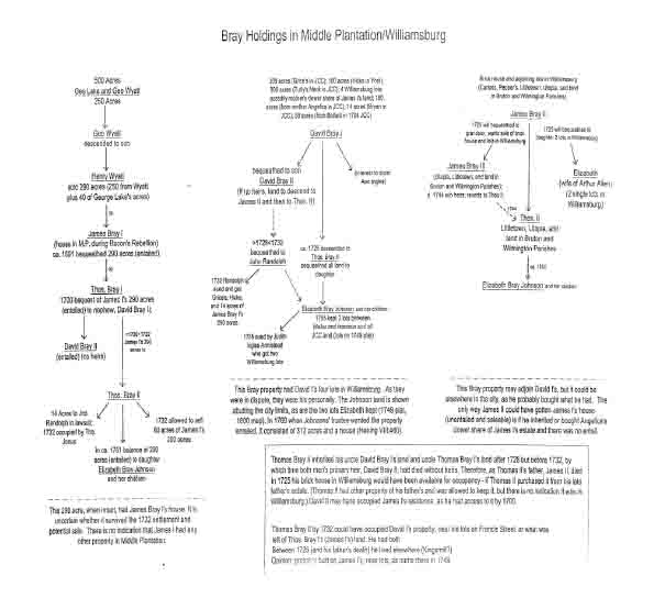 Bray Holdings in Middle Plantation/Williamsburg
28
that George Wyatt and George Lake had acquired during the 1640s (Nugent 1969-1979:I:161; Patent Book 2:54, 59; Winfree 1971:383; Stephenson 1963:2).
Bray Holdings in Middle Plantation/Williamsburg
28
that George Wyatt and George Lake had acquired during the 1640s (Nugent 1969-1979:I:161; Patent Book 2:54, 59; Winfree 1971:383; Stephenson 1963:2).
By the mid-1670s, James Bray I and his wife, Angelica, were residing at Middle Plantation. She was one of the women seized by the men of rebel Nathaniel Bacon in September 1676 and used as part of a human barricade. On January 20, 1677, a court martial hearing was held at the Bray home in Middle Plantation where Bacon supporter William Drummond I was tried and sentenced to hang. The following day Governor William Berkeley stopped off at the Bray residence and then continued on to the home of Colonel John Page, where he planned to spend the night. In February 1677 James Bray I was asked to obtain land at Middle Plantation for the king's troops' use in growing food crops. He was named to the Governor's Council in 1679 and in 1688 he became one of James City County's burgesses (McIlwaine 1924:257, 393-394, 454; 1905-1915:1660-1693:72; 1925-1'945:I:284; II:435; Sainsbury 1964:10:341; 17:309; 22:158; Hening 1809-1823:II:546, 549, 569; Stanard 1965:86, 94-95; Leonard 1976:60; Force 1963:I:9:8; Andrews 1967:98).
When James Bray I died in ca. 1691, he still owned the 290 acres he had bought from Henry Wyatt. He also was in possession of some other local acreage and land in nearby Charles City and New Kent Counties. James Bray I was survived by his wife, Angelica, three sons (James II, Thomas I, and David I) and a daughter (Ann). Although his will is not believed to be extant, excerpts of that document are included in a transcript of litigation undertaken in 1732 by some of his heirs. The late James Bray I left to his son, Thomas Bray I, life-rights in all of the entailed land he owned at Middle Plantation, including the family home. At that time it was noted that the property consisted of the 290 acres James Bray I had bought from Henry Wyatt, which origin lay in a 500 acre tract that George Wyatt and George Lake formerly had owned. Bray, as a testator, stipulated that after the death. of his son, Thomas I, his land at Middle Plantation was to descend to grandson David Bray II, the offspring of another son, David Bray I. Through this means, James Bray I's 290 acres at Middle Plantation passed through the hands of Thomas I and then descended to David II. James Bray I specified that if his grandson, David Bray II, failed to produce living heirs, the 290 acre tract at Middle Plantation was to go to.another grandson, Thomas Bray II, the offspring of son James Bray II (Nugent 1969-1979:1:161; Winfree 1971:383; McIlwaine 1924:257, 393- 94, 454; 1905-1915:1660-1693:72; 1925-1945:I:284; II:435; Stephenson 1963:2). Thus, the will of James Bray I, deceased in ca. 1691, determined the descent of the Bray landholdings in Middle Plantation.
Angelica Bray (Mrs. James Bray I)
In 1695 Angelica Bray, James Bray I's widow, patented 190 acres of escheat land, the bulk of which lay in James City County. However, a small portion of Angelica's property extended across the main road, to Yorktown (the boundary line between York and James City Counties) and therefore was in York County. Angelica Bray's 190 acres reportedly lay adjacent to her late husband, which contained the family home (Nugent 1969-1979:III:18). At Angelica's death, her personally-owned acreage descended to one of her sons, David Bray I (Hening 1809-1823:IV:377-378; VI:412).
Thomas Bray I (son of James Bray I)
Relatively little is known about Thomas Bray I, who inherited life-rights in the entailed property of his father, James Bray I, 290 acres of land at Middle Plantation that contained the family home. Thomas I, who made his will on May 21, 1700, apparently died unmarried and childless. In accord with his late father's wishes, he bequeathed his land at Middle Plantation, which was entailed, to his nephew, David Bray II, assigning the remainder to David Bray I (the testator's brother). However, he named another nephew, Thomas Bray II, the son of James Bray II, as reversionary heir to the entailed property. Thomas Bray II also stood to inherit from his uncle, Thomas Bray I, some land on Black Creek in New Kent County. According to Mary Stephenson, from 1698 to 1700, Thomas Bray I was a vestryman of St. Peter's Parish in New Kent County (Stephenson 1963:3; Winfree 1971:381). A January 24, 1700, deed for a 300 acre tract transferred by William Hansford to James Whaley made reference to the "main road" and to the boundaries of properties then owned by John Page, Thomas Bray, William Dyer and "Madam Bray" (York County Deeds, Administrations, Bonds 1:259-260). These descriptive data make reference to the Page and Dyer property in York County which location is known, and place Thomas Bray I's land in the vicinity of the tract known as Bassett Hall and that of "Madam Bray" (probably the 190 acres Angelica Bray patented in 1695), which was contiguous and to the east.
David Bray I (son of James Bray I)
David Bray I, who was born in 1666, was one of James Bray I's three sons. However, David I's brother, Thomas I, probably the eldest, was their father's primary heir and inherited his 290 acres in Middle Plantation, the entailed acreage that contained the family home (Winfree 1971:383). David Bray I, who in 1705 became a Bruton Parish vestryman, inherited the 190 acres at Middle Plantation that his mother, Angelica, patented in 1695. He also acquired several tracts of local land through a series of purchases. In James City County he was in possession of 300 acres called Tutty's Neck on Archer's Hope Creek, 200 acres called Grices, 14 acres he bought from the Bryans, and 50 acres he procured from Thomas Ballard II in 1704. In York County, he owned 100 acres known as Hicks. In 1704, David Bray I paid quitrent upon 5,758 acres of James City County land, but none in York County. He and his wife, Judith, produced one living heir, their son, David Bray II (Hening 1809-1823:IV:377-378; VI:412; Stephenson 1963:4; Wertenbaker 1922:211).
Official records reveal that in 1699, when the city of Williamsburg was laid out, part of David Bray I's land fell within its boundaries (McIlwaine 1918:751). As the rest of the fledgling community was derived from the landholdings of Daniel Parke II, Colonel John Page's heirs, and Thomas Bray II (the late James Bray I's heir who held life-rights), it is probable that by 1699 David Bray I had come into possession of the acreage Robert Weekes had owned in 1678, a long, narrow tract that probably extended from Boundary Street to Nassau Street and from the vicinity of Scotland Street to a point just below the town limits (Beverley 1678).
David Bray I and his wife, Judith, produced a son, David Bray II, who stood to inherit the late James Bray I's land at Middle Plantation after it had passed through the 30 hands of Thomas Bray I. However, when Thomas Bray I made his will, he gave his brother, David I, life-rights to the acreage he owned outright and named a nephew, Thomas Bray II (the son of James Bray II) as his reversionary heir (Winfree 1971:381; Hening 1809-1823:VI:412).
David Bray I apparently took an active, role in the development of Williamsburg, for in October 1705 he was designated a city trustee (Hening 1809-1823:III:431). On October 21, 1717, when he made his will, he left all of the real estate he owned outright to his son, David II, who between 1728 and 1731 married Colonel John Page's great-granddaughter Elizabeth Page. David Bray I stipulated that if David II failed to produce living heirs, his land, which was entailed and could not be sold, was to go to James Bray II (the testator's brother) and James II's male descendants. If James II failed to produce a male heir, David Bray I's land was to be divided between James II's female heirs and the heir of David I and James II's late sister, Ann, who had been the wife of Mungo Ingles. Thanks to these bequests, Thomas Bray II, as surviving male heir, stood to inherit all of his grandfather's property at Middle Plantation; the landholdings of his uncle, David I; and the acreage that had belonged o his father, James Bray II (Winfree 1971:381-383; Hening 1819-1823:VI:412-415). At the time of David Bray I's death, the trustees for the city of Williamsburg still owed him money for that portion of his land which had been acquired in 1699 when the city was laid out (McIlwaine 1918:751). That debt, still unpaid in March 1728, descended to his son, David Bray II.
A law suit, aired before the House of Burgesses in 1755, resulted in the passage of a legislative act that resulted in the partitioning of the Bray property. It noted that David Bray I, at the time of his death, owned four lots in the city of Williamsburg; several pieces of land in James City County (totalling approximately 950 acres); and an 1,850 acre tract in Charles City County known as Nance's Neck. Again, reference was made to the fact that if David Bray II failed to produce heirs, his late father's land was to revert to James Bray II and his male heirs. If James II failed to produce such heirs, Davis I's land was to be divided between James II's female heirs and the only daughter and heir of Ann Bray Ingles, David Bray I's deceased sister (Hening 1809-1823:VI:412-415).
Ann Bray Ingles (daughter of James Bray I)
Ann, the daughter of James Bray I and his wife, Angelica, married Robert Booth, who died in 1693. Two years later she wed Peter Temple of Vaulx Hall, in York County. In 1695 Peter Temple, acting on his wife's behalf, sold her legal interest in James Bray I's estate to her brother Thomas Bray I for 150 pounds sterling. After Peter's death in 1698, Ann Bray Booth Temple married Mongo (Mungo) Ingles (Stephenson 1963:8).
In 1717, when Ann's brother, David Bray I, made his will, he specified that if his son, David II, failed to produce legal heirs, his land was to be divided between her and his brother, James II. Thanks to these bequests, Ann Bray Ingles' daughter and sole heir, Judith Ingles Armistead, inherited a legal interest in the property of her late uncle, David Bray I (Winfree 1971:381-383; Hening 1809-1823:VI:412-413). At the time of David Bray I's death, the trustees for the city of Williamsburg still owed him money for that portion of his land which had been acquired in 1699 when the city was laid out (McIlwaine 1918:751). In November 1755, when the assembly partitioned the late David Bray I's property and distributed it between his legal heirs (Judith Ingles Armistead and Elizabeth 31 Bray Johnson), it was noted that David Bray I, at the time of his death, owned four lots in the city of Williamsburg; 950 acres of land in James City County; and an 1,850 acre tract in Charles City County. A 1769 description of the property assigned to Elizabeth Bray Johnson reveals that the 950 acres she had received as a result of the 1755 partition suit included a 312 acre tract and a dwellinghouse adjoining the city of Williamsburg and 600 acres called Tutty's Neck (Hening 1809-1823:VI:412-415; McIlwaine 1905-1915:1766-1769:279). Thus, the dwelling owned by the late David Bray I, which descended through Thomas Bray II to Elizabeth Bray Johnson, was on acreage adjoining Williamsburg but not within the city limits.
David Bray II (son of David Bray I)
As noted above, David Bray II, the son of David Bray I and his wife, Judith, married Elizabeth Page, the daughter and sole heir of Francis Page's daughter, Elizabeth,. and her husband, John Page of Gloucester County. Sometime after October 1717, David Bray II inherited his late father's property as well as a reversionary interest in the estate of his late grandfather, James Bray I, which had descended to him through his late uncle, Thomas Bray I (Winfree 1971:381). Elizabeth Page and David Bray II wed sometime after March 1728, at which time her business affairs were being handled by her stepbrother (McIlwaine 1918:751).
David Bray II and his wife, Elizabeth, failed to produce living heirs and on June 4, 1731, when he made his will, he bequeathed all of the real and personal property in his possession to Sir John Randolph of Williamsburg. The testator overlooked or perhaps purposefully ignored the fact that his late father, David I, and his late grandfather, James I, had named Thomas Bray II (the son of James Bray II) as their reversionary heir, if David II failed to produce an heir (Winfree 1971:381-383). Interestingly, David Bray II made no mention of his wife, Elizabeth, or her entitlement to a dower share of his estate.
The widowed Elizabeth Page Bray, who was the sole surviving heir of her maternal grandfather, Francis Page, inherited his property in Williamsburg and its environs. This would have included the Page home constructed by her great-grandfather, Colonel John Page, and the 168 acres Colonel Page had given his son, Francis. When Elizabeth Page Bray died childless in 1734, ownership of the land she had inherited from her great-grandfather, which had descended to her through her maternal grandfather and her mother, reverted to Mathew Page and his descendants. Through this means, Mann Page I, the son of Mathew and Mary Mann Page, inherited the Page property in Middle Plantation. In January 1730, when Mann Page I made his will, he left his legal interest "in the lands late of my Uncle Mr. Francis Page and which are now in the possession of Mr. David Bray [II] to my son Carter." This raises the possibility that David Bray II and wife Elizabeth may have occupied the Page homeplace near Williamsburg, instead of one of the properties he inherited. In September 1744 Mann Page I's son and heir, Mann II, received the assembly's permission to sell off some of the entailed property he had inherited from his late father. Included was the Page land that had belonged to Elizabeth Page Bray, which Mann Page I had left, to his son, Carter Page, who had died without heirs. This left Mann II as residual heir (Meyer et al. 1987:412; Hening 1819-1823:V:279-281).
James Bray II (son of James Bray I)
James Bray II, the son of James Bray I, married Mourning Glenn Pettus, widow of the late Thomas Pettus of Littletown (later Kingsmill) plantation in ca. 1697. Through their union, James II inherited Mourning's legal interest in her former husband's property. James Bray II and his sister, Ann Bray Ingles, inherited from their brother, David I, a residual interest in his property (Hening 1809-1823:VI:414-415; Goodwin 1972:56). In 1700 James Bray II purchased from the Walker and Pettus heirs "all those tracts called or known by the name or names of Littletown and Utopia… containing 1280 acres." He also bought a 500 acre tract that straddled the line between New Kent and James City Counties (Stephenson 1963:6).
James Bray II and his wife produced at least three children who lived to adulthood: Thomas II, who married Elizabeth Meriwether; Angelica, who married Henry Baker; and Elizabeth, who married Arthur Allen, the builder of Bacon's Castle. After Arthur Allen's death in 1711, Elizabeth wed Arthur Smith, who died in 1728. Her third and final husband was William Stith of Charles City County, whom she married sometime prior to 1763. James Bray II and his wife, Mourning, lived at what became Kingsmill Plantation, where he unified the Littletown and Utopia tracts and built a substantial home. However, he also had a brick house and lots in Williamsburg. Mourning died in 1711 (Stephenson 1963:5, 12; Fry and Jefferson 1751).
The will James Bray II made on November 17, 1725, was presented for probate on March 14, 1726. He left to his son, Thomas II, "all his real and personal estate now in [his] possession" and stipulated that his "Brick House and lets belonging thereto at Williamsburg" were to remain in the hands of his executor until the same can be sold by son, Thomas." The funds derived from the sale were to go toward the education and maintenance of the testator's grandson, James Bray III, who also stood to inherit his grandfather's land in Wilmington and Bruton Parishes. James Bray II bequeathed to his daughter, Elizabeth Allen, life-rights to the Pettus plantation, Littletown, until James Bray III came of age, and he left to Elizabeth "forever" the plantation called Rockahock on the Chickahominy River. Elizabeth Allen and her sister, Angelica Baker, were authorized to keep "all personal and real estate formerly delivered to them forever" and he bequeathed to Elizabeth "two single lots in Williamsburg forever" (Stephenson 1963:5; Winfree 1971:382; C.O. 5/1389 ff 66-68) .
Although James Bray II's will reveals that he had a brick house and lots in Williamsburg, plus the two single lots that he bequeathed to his daughter, Elizabeth, nothing in that document reveals how he acquired his lots or precisely where they were located. However, when daughter Elizabeth Bray Allen Smith Stith made her will in 1764, she bequeathed to her granddaughters "my House and Lots adjoining the Lott which Dr. Hay purchased of Col. Philip Johnson and Facing the Lott where the Doctor formerly lived." Elizabeth also left to James Allen Bridger "my single Corner Lott lying near the Colledge & facing the Lott where Mr. Cambell formerly lived" (Stephenson 1963:7, 12-13) . This may be one of the two lots she inherited.
Thomas Bray II (son of James Bray II)
Thomas Bray II, who was wed to Francis Meriwether II's daughter, Elizabeth, produced a son, James Bray III, and a daughter, Elizabeth, who married Philip Johnson. As previously 33 noted, the late James Bray I left to his son, Thomas Bray I, life-rights to all of the land he owned at Middle Plantation, which was entailed: the 290 acres James I had bought from Henry Wyatt. James I stipulated that after the death of Thomas I, is land as to descend to grandson David Bray II, the offspring of David Bray I. Through this means, James Bray I's 290 acres at Middle Plantation, which contained his home, passed through the hands of son Thomas I and then went to grandson David II. James Bray I specified that if David Bray II failed to produce living heirs, his 290 acre tract at Middle Plantation was to go to another grandson, Thomas Bray II, the son of James Bray II (Winfree 1971:383; McIlwaine 1924:257, 393-394, 454; 1905-1915:1660-1693:72; 1925-1945:I:284; II:435; Stephenson 1963:2). Through this means, James Bray I's landholdings in Middle Plantation eventually came into the possession of his grandson, Thomas Bray II. Thomas II also had a surviving legal interest in the land that his uncle, Thomas Bray I, had left to David Bray I and David Bray II, and he inherited from Thomas Bray I exclusive ownership of a tract of land on Black Creek, in New Kent County (Winfree 1971:381).
After David Bray II's death, which occurred between June 1, 1731, and May 18, 1732, Thomas Bray II decided to sell some of the entailed property he had inherited, which was supposed to descend to his son, James Bray III. As Sir John Randolph, whom David II had designated as his sole heir, asserted a legal claim to of the Bray estate, the matter was aired before the House of Burgesses. Although Thomas Bray II contended that he (and ultimately his son) were entitled to the Bray land under the wills of their forebears, John Randolph claimed that as James Bray I had predeceased David Bray II, David II's will was binding. Ultimately, Randolph's claim was upheld and the Bray estate was partitioned. At a result, John Randolph was given land that David Bray I had purchased outright and left to son David II: a tract called Grices; which was said to be in Barret's Neck of Martin's Hundred in James City County, plus a 100 acre tract called Hicks in York County, which David Bray I had bought from Mary Whaley. Randolph also was assigned 14 acres that originally had been part of a 290 acre tract that Thomas Bray I had left to his nephew, Thomas Bray II, seemingly a portion of the 290 acres James Bray I once owned in Middle Plantation. The latter 14 acre parcel was described as "inclosed land, in the occupation of Thomas Jones, gentleman, adjoining to the land of the said John Randolph," who had a plantation on the east side of the road to College Landing (Hening 1809-1823:IV:372; McGhan 1993:843-844).24 Thomas Bray II, on the other hand, received a tract that David Bray II's mother, Judith, had bought from Frederick Jones (Tuttey's Neck, which consisted of 300 acres in James City County) and the Bryan tract (14 acres in James City County that David Bray II had purchased), 34 plus the 190 acre plantation his paternal grandmother, Angelica Bray (Mrs. James I) had owned, which straddled the line between James City and York Counties. On May 28, 1732, each man signed a quit claim deed, formally relinquishing his right to assert a claim to the property the other had been assigned (Winfree 1971:382-383; Hening 1809-1823:IV:371-377).
Afterward the assembly formulated an act that made it possible for Thomas Bray II to sell some of his land. Reference was made to Thomas Bray I's 1700 bequest to his nephew, Thomas Bray II, and Thomas I's assignment of the remainder to David Bray I. It also was noted that David Bray I had left all of his land to his son, David Bray II, stipulating that if he should die without male heirs, his acreage was to descend to James Bray II and his heirs. Thomas Bray II indicated that James Bray II, in his November 17, 1725, will, had devised his James City County plantation called Littletown to his daughter, Elizabeth Bray Allen, until the testator's grandson, James Bray III came of age. He added that he wanted to purchase Mrs. Allen's life-interest in Littletown on behalf of his son. Thomas Bray II also said that under the terms of James Bray II's will, James Bray III, upon attaining the age of 21, stood to inherit the rest of his grandfather's (James Bray II's) entailed property in Wilmington and Bruton Parishes. He asked the assembly to dock the entail upon the vast quantity of acreage he and his son (James III) had inherited, so that slaves could be purchased to work the land, which he described as "a Burthen instead of a Benefit" until it could be made productive. He said that he wanted to raise the sum of 2,000 pounds sterling by selling some or all of several parcels of land: Black Creek in New Kent County; Toryham, Naaman's Fields and Grices in Charles City; Sander's, Pepper's, and Carloss's; and three other pieces of real estate in James City and York Counties (50 acres that David Bray I bought from Thomas Ballard on December 6, 1704; 60 acres adjoining the city of Williamsburg that was part of the 290 acres that the late James Bray.I had bought from Henry Wyatt; and 40 acres in York County that was part of the 190 acre tract Angelica Bray had patented). Thomas Bray II indicated teat the slaves he purchased with the money he raised would be settled upon the entailed property that belonged to him and his son. Before legislation could be enacted, authorizing Thomas Bray II to sell some entailed land, a notice had to be published in the churches of the parishes in which the property was located. If no legally binding claims were forthcoming, he had the right to dispose of as much of the land as he needed to, to raise 2,000 pounds sterling, afterward annexing the slaves he bought to the entailed land. Thomas Bray II was obliged to provide the assembly with an account of the land he sold and the slaves he bought. Trustees were appointed to oversee both transactions. As it turned out, Thomas Bray II outlived his son, James III, and on May 7, 1751, when he made his will, he left fee simple ownership of a moiety of the land he had inherited to his daughter, Elizabeth, the wife of Colonel Philip Johnson, then of King and Queen County. He also designated Benjamin Waller and William Prentis as trustees of his daughter's land and slaves (Winfree 1971:382-3 4; Hening 1809-1823:IV:371-377; VI:413-415).
James Bray III (son of Thomas Bray II)
James Bray III, who in 1725 inherited the Pettus plantation called Littletown and property in Wilmington and Bruton Parishes from his grandfather, James Bray II, combined 35 Littletown with his own land, developing the whole into what eventually became the eastern part of Kingsmill Plantation. In October 1734 James Bray III brought suit against his own father, Thomas II, in an attempt to force him to relinquish the funds gleaned from the sale of James Bray II's house and lots in Williamsburg. James III alleged that although his father had sold the late James Bray II's land, as he was supposed to, in accord with the terms of the decedent's will, he had not re-invested the sale monies in slaves that were annexed to the late James Bray II's other entailed lands. Special commissioners were appointed to determine how much land had been sold and what became of the money. Finally, in May 1740 Thomas Bray II was ordered to complete the transactions he had begun, but not to sell any more land, and to annex the slaves he purchased to his son's remaining entailed lands. Failure to comply with the court order would place him in violation of the law (McIlwaine 1905-1915:1724-1734:228; 1736-1740:330, 395).
In 1740 James Bray III married Frances Thacker of Gloucester County. The couple made their home at what became Kingsmill. James Bray III died in 1744, without having produced heirs. As a result, the bulk of the property he had inherited from his forebears reverted to his father, Thomas Bray II, from whom it was to descend to James III's sister, Elizabeth Bray Johnson, and her heirs. Meanwhile, the widowed Frances Bray married her neighbor, Lewis Burwell, who owned the property to the west of the home she and her late husband had shared. Later, the Burwell couple sought to recover Frances's legal interest in James Bray III's estate by bringing suit against Thomas Bray II's daughter, Elizabeth, and her husband, Philip Johnson. Witnesses who appeared on behalf of the defendants claimed that the Burwell couple had spirited away a wagonload of furniture, household goods, two slaves, and six steers. The late Thomas Bray II's daughter, Elizabeth, who was then wed to Arthur Smith, said that she had consulted an attorney, who told her that if James Bray III died without a male heir, his inheritance would revert to their father, Thomas Bray II. She added that the late James Bray III often had said that if he did not have a son, his sister (Elizabeth Bray Johnson) would inherit their grandfather's property. Mrs. Smith indicated, that she had heard that James Bray III was deeply in debt and had little to leave his wife, Frances. Peter Hay testified that Frances Bray Burwell was willing to relinquish her claim to James Bray III's estate, if Philip Johnson would pay her 500 pounds sterling; he refused (Hening 1809-1823:VI:412-413; Stephenson 1963:11, 36, 42-45).
In November 1755 the House of Burgesses enacted legislation for the purpose of making an equitable distribution of certain Bray family property. Philip Johnson, the husband of Thomas Bray II's daughter and only heir, Elizabeth, asserted a claim to her legal interest in the property once owned by the late David Bray I and left to his surviving siblings (James Bray II and Ann Bray Ingles) if son David Bray II failed to produce heirs. William Armistead, who had married, Judith, the daughter and only heir of Ann Bray Ingles, asserted a claim to the same property. In November 1755 when the burgesses partitioned the late David Bray I's estate, they noted that at the time of his death he owned four lots in the city of Williamsburg; several pieces of land in James City County (totalling approximately 950 acres); and an 1,850 acre tract in Charles City County known as Nance's Neck (Hening 1809-1823:VI:412-415) (see ahead).
Elizabeth Bray Johnson (daughter of Thomas Bray II)
Elizabeth Bray was the daughter of Thomas Bray-II and his wife, Elizabeth Meriwether. On May 7, 1751, when Thomas II (who had outlived his son, James Bray III) made his will, he left fee simple ownership of a moiety of the land he had inherited to his daughter, Elizabeth, then the wife of Colonel Philip Johnson of King and Queen County. However, Thomas Bray II named Benjamin Waller and William Prentis as trustees of Elizabeth's inheritance, which was intended for her children. In October 1752 Elizabeth's husband, Philip Johnson, brought suit against the two trustees, at. which time Williamsburg's Chancery Court decided that Philip was entitled to a life-interest in a dower share of his wife's inheritance but that John Robinson was to serve as trustee for Philip's and Elizabeth's children, the reversionary heirs. Later, James Bray III's widow, Frances, who married Lewis Burwell, brought suit against Philip and Elizabeth Bray Johnson in an attempt to recover part of Thomas Bray II's estate (Winfree 1971:382-384; Hening 1809-1823:VI:414-415; Stephenson 1963:11).
Besides falling heir to her late father's land, Elizabeth Bray Johnson inherited a legal interest in the acreage that her great-uncle, David Bray I, had left to her grandfather, James Bray II, and his descendants. Elizabeth's aunt, Judith Ingles Armistead, also had a legal interest in David Bray I's estate, for he had made a bequest to his sister, Ann Bray Ingles, Judith's mother. At issue were the four Williamsburg lots that David Bray I owned at the time of his death; several pieces of land in James City County (totalling approximately 950 acres); and a 1,850 acre tract in Charles City County known as Nance's Neck (Hening 1809-1823:VI:413).
In November 1755 the House of Burgesses partitioned the late David Bray I's land, at which time the tract known as Nance's neck and two of the decedent's lots in the city of Williamsburg (on Francis Street, adjoining the lots of Dudley Digges and James Spiers) were assigned to William Armistead and his wife, Judith. Simultaneously, all of the late David Bray I's land in James City County and his other two lots on Francis Street (described as situated between the lots of Benjamin Harrison and Benjamin Waller) were vested in John Robinson, the trustee for Philip and Elizabeth Bray Johnson's children. A 1749 plat by William Waller identifies the location of the latter two lots, which were attributed to Col. Tho. Bray. Both were on the south side of Francis Street, just west of the point where Waller and Francis Streets intersect. As the Nance's Neck tract assigned to the Armisteads was deemed more valuable than the James City County land the Johnsons received, they were obliged to pay the Johnson children's trustee 390 pounds sterling (Hening 1809-1823:VI:413; Waller 1749).
In November 1769, shortly after the death of John Robinson, the Johnson children's trustee, the House decided to vest in Philip Johnson certain property that his children stood to inherit. The assembly minutes note that Robinson had been responsible for a dwellinghouse and 312 acres of land adjoining Williamsburg, except for 19 acres and 26 poles of land, which had been laid off and annexed to the city. Also included in the acreage for which the Johnson children's trustee was responsible were 43 acres Philip Johnson had purchased from John Baskerfield, 600 acres known as Tutty's Neck, and two half-acre lots on Francis Street in Williamsburg, parcels that were situated between lots owned by William Pasteur and Benjamin Waller. Reference was made to the fact that when Elizabeth Bray Johnson died, she left behind Philip and their seven children. 37 In November 1769 the assembly designated Peyton Randolph, Robert Carter Nicholas, Lewis Burwell and Philip Whitehead Claiborne as trustees for the Johnson children. They were empowered to sell the property at public auction, if they saw fit (McIlwaine 1905-1915:1766-1769:279; 1770-1772:8; Hening 1809-1823:VIII:460-463).
A plat depicting Williamsburg's streets and lots, that dates to 1800, includes the Johnson children's two lots on Francis Street, which were situated between a lot owned by Semple and Waller. Also shown were the two rows of lots created out of the 19 acres and 26 poles of land taken from the Johnson acreage and added to the city of Williamsburg. The acreage abutting the south side of the 19-plus urbanized acres was attributed to Colonel Philip Johnson. As previously noted, Colonel Johnson had life rights in a dwellinghouse and 312 acres of land adjoining the city (McIlwaine 1905-1915:1766-1769:279).
Adjoining the Bray-Johnson subdivision was some acreage that Benjamin Waller had purchased from Mann Page II on December 13, 1743. Of that property, 745 acres, which reportedly adjoined the east, north and west sides of Williamsburg, had descended from Colonel John Page to his son, Francis, through whom it had passed to the colonel's great-granddaughter, Elizabeth. As Elizabeth and her husband, the late David Bray II,. had failed to produce living heirs, the 745 acre tract had descended to Mann Page I as reversionary heir and then to his son. Mann Page II already owned a contiguous 200 acre parcel on the east side of Williamsburg, acreage he had purchased from Elizabeth Page Bray earlier on. Waller, shortly after gaining possession of Mann Page I's acreage, had part of it subdivided and laid off into lots (Stephenson 1963:9, 40; Waller 1743; Hening 1809-1823:V:277-278). A plat of the Waller subdivision on the south side of York Street, prepared by William Waller in April 1749, shows, the lots' alignment and the common boundary line the Page property shared with the Bray/Johnson acreage. This somewhat irregular angular line, on the southeast side of Williamsburg, most likely represents the southernmost limits of the 330 acre tract that Colonel John Page patented as an aggregate in 1683. This interpretation of the Page/Bray property line is shown on the map entitled "Middle Plantation, 1699/1700."
Bray Property Associated with the Ballard Family
During the 1670s the Ballards owned some land adjacent to what became the college tract, plus the 130 acres that Thomas Ballard I bought from John Peters and Nicholas Wattkins' heirs in 1667. Mid-seventeenth century patents reveal that in October 1645 Richard Popeley, the owner of 1,250 acres at Middle Plantation, deeded a 100 acre parcel to Nicholas Wattkins, who acquired an additional 30 acres as a headright. On October 21, 1667, Wattkins sold his 130 acres to John Peters, who sometime prior to July 20, 1667, conveyed it to Thomas Ballard I. After the sale occurred, Nicholas Wattkins' remarried widow, Margaret Miles and her new husband, John, and Nicholas's daughter, Elizabeth Richard, and her husband, George, relinquished their legal interest in the decedent's property. In 1704 Thomas Ballard II sold 50 acres of the Wattkins tract to David Bray I (Beverley 1674, 1678; Westmoreland County Deeds and Wills 1 [1653-1671]:363-364; Deeds, Patents Etc. 1665-1677:61a-62; Hening 1809-1823:IV:383; Patent Book 2:55-56). The Ballard/Bray land is identified as part of the Bray holdings on the electronically generated tract map designated "Middle Plantation, 1699/1700." The Ballard tract abutting the college land also is shown.
Cultural Features Associated with the Bray Property
James Bray I owned at least 290 acres of land at Middle Plantation, acreage he purchased from George Wyatt's son, Henry. The Wyatt property, which abutted northwest upon the Middle Plantation palisade, enveloped much of the easterly part of what became Williamsburg. James Bray I built a home in Middle Plantation sometime prior to Bacon's Rebellion. When he died in ca. 1691, he was survived by a widow (Angelica), three sons (Thomas I, David I, and James II), and a daughter (Ann). He left the bulk of his Middle Plantation property, which was entailed to son Thomas Bray I. In 1700, when Thomas Bray I made his will, he left his land at Middle Plantation to his nephew, David Bray I but stipulated that if he failed to produce heirs, the acreage was to descend to another nephew, Thomas Bray II. Thomas Bray I gave his brother, David I, life-rights to the rest of his acreage, naming nephew Thomas Bray II as reversionary heir. When the childless David Bray II made his will in 1731, he ignored the reversionary rights of his cousin, Thomas Bray II, and bequeathed all of his property to John Randolph. In 1732, when the late David Bray II's property was partitioned, Randolph was given land that David Bray I had bought, personally, which David I had inherited, plus 14 acres of Thomas Bray I's estate. Simultaneously, Thomas Bray II received two tracts that David Bray I and his wife had bought, plus a 190 acre plantation that his grandmother, Angelica Bray (Mrs. James I) had owned, which straddled the line between James City and York Counties.
If the dwelling site near the Chiswell house dates to the fourth quarter of the seventeenth century, it may be associated with the occupancy of James Bray I and his descendants. On the other hand, the archaeological features near the Dana house are located upon the neighboring lots that in 1749 were owned by Thomas Bray II and had descended to him from his uncle, Thomas Bray I, after passing through the hands of David Bray II. In 1732 Thomas II sought to dock the entail upon several properties that he had inherited. One was a 60 acre tract adjacent to Williamsburg, part of the land that James Bray I had purchased from Henry Wyatt. Another was 40 acres of the land that had belonged to his grandmother, Angelica (Mrs. James I) Bray. In 1755 when Judith Ingles Armistead and her husband brought suit against Thomas Bray II's heirs in an attempt to recover a share of David Bray I's estate, at issue were four lots within the city of Williamsburg and parcels in Charles City and James City County. The Armisteads were awarded two lots (between Dudley Digges and James Spiers) and Thomas Bray II's grandchildren (Philip and Elizabeth Bray Johnson's children) were assigned two lots between Benjamin Waller and Benjamin Harrison. The division of the lots between David Bray I's heirs indicates that they had once been in his possession. A 1749 plat of some adjoining property reveals that the lots the Johnsons inherited from Thomas Bray II were located upon the south side of Francis Street, within Block 2. Behind the lots was acreage also attributed to Colonel Thomas Bray II. Near the college tract there also was some acreage that appears to have belonged to David Bray I.
Benjamin Harrison Jr.'s Houses
In 1705, the assembly made an exception to their newly formulated building code for the city of Williamsburg, for they decided that the houses that Benjamin Harrison Jr. 39 had erected upon his four half-acre city lots, before construction guidelines had been established, could remain (Hening 1809-1823:III:430).25 As no York County deeds have come to light that pertain to Benjamin Harrison Jr.'s lots, they probably were located in James City County. Harrison in 1703 served as a burgess for James City County, and in 1704 owned 100 acres there. He may have bought some of the lots between Henry Street and Jamestown and Richmond Roads, acreage that previously had belonged to the college, for he was one of its trustees and a member of the college's Board of Visitors (C.O. 5/1310 f 82). On the other hand, he may have purchased part of the land that in 1678 belonged to Robert Weekes, which research suggests came into the hands of David Bray I sometime prior to 1699. In 1705, Governor Francis Nicholson claimed that Mr. Harrison had offered to rent him a dwelling at an exorbitant annual rate, unless he signed a long-term lease. Nicholson said that the dwelling "daily decays" and that he ha[d] decided to rent a house from Madam Page, instead (Sainsbury 1964:22:430-431). Nicholson probably preferred to reside close to the college, a focal point of government activity until the capitol was readied for use. The property owned by Benjamin Harrison Jr. should not be confused with that of his sons, Nathaniel and Benjamin, who purchased lots in Williamsburg.
THE CUSTIS FAMILY HOLDINGS
Throughout much of the eighteenth century, members of the Custis family owned property that abutted the lower (or southeast) side of Francis Street. As Daniel Parke II owned land in Middle Plantation which descended to his daughter, Frances, and. her husband, John Custis IV, it was through this means that the Custis family came into possession of the property traditionally associated with them.
Daniel Parke (Park) II
Daniel Parke II, the son of Daniel Parke I, was born in 1669. He served in the Parliament and was implicated in a bribery scandal. He distinguished himself at Blenheim, where he gained the admiration of Marlborough, and married Jane, the daughter of Lucy and Philip Ludwell I of Fairfield, in Gloucester County. Together, Daniel and Jane Ludwell Parke produced two daughters: Lucy, who married William Byrd II of Westover and Frances, who wed Colonel John Custis IV of Arlington. Parke, who loved dueling, was known for his volatility. He was a handsome man and reputedly was a notorious rake (Withington 1980: 64, 335, 337, 344; Byrd 1941:xi, 102; Stanard 1965:43).
In 1692 Daniel Parke II was named to the Governor's Council. He also became a naval officer and in 1693 was elected a burgess for both James City and York Counties. When forced to decide which county to represent, he chose James City. In 1696, Parke, while visiting the Rev. James Blair at Middle Plantation, got into a heated argument with Maryland governor Francis Nicholson, whom he delighted in antagonizing. According to Blair, Parke goaded Nicholson into insulting him, then retaliated by striking 40 him upon the head with a horsewhip and challenging the Maryland governor to a duel. Only Nicholson's having left his sword at Jamestown kept the two men from combat. Daniel Parke II reportedly got along well with Governor Edmund Andros and it was during his administration that Parke became the colony's escheator and collector of customs (Stanard 1965:43, 88; Withington 1980:164, 335, 337, 344; McIlwaine 1905-1915:1660-1693:450; 1918:194; 1925-1945:I:339, 360; Leonard 1976:53; Perry 1969:1:28).
Colonel Daniel Parke II owned a vast amount of acreage in York, James City, King William and New Kent Counties and in 1693 he purchased 17 acres from William Sherwood at Middle Plantation. The Sherwood parcel, which lay within James City County, originally had been part of George Lake's acreage and probably was the property upon which William Sherwood and Thomas Rabley had constructed buildings to house the king's troops and some military stores (Sherwood 1693; Smith 1957:69; McIlwaine 1925-1945:II:74).
In March 1702, when Daniel Parke II's daughter, Frances, began making plans to marry John Custis IV, Parke promised to give Frances a dowry equal to half of what Custis could prove that he was worth. Parke also asked his son-in-law to "live at his house" in Williamsburg. Some scholars believe that he did (Stephenson 1959:Illustration #4).
On April 25, 1704, Daniel Parke II was named governor of the Leeward Islands. Six years later, he was brutally murdered by angry mob in St. John, Antigua. On January 1, 1710, when Parke prepared his will, he made monetary bequests to two of his illegitimate children and left to his daughter Frances Custis property in Virginia and England, along with his outstanding debts. He also bequeathed a substantial sum of money to daughter Lucy, the wife of William Byrd II of Westover. It was probably through Daniel Parke II's dower agreement with John Custis IV that Parke's 17 acres at Middle Plantation came into Custis's hands, land that in 1699 became part of Williamsburg. Years later, when a law suit was undertaken against John and Frances Parke Custis's grandson, Daniel Parke Custis, a March 17, 1702, letter from Daniel Parke to John Custis IV was cited wherein Daniel asked to live "at his house" in Williamsburg (Withington 1980:164, 325, 327, 344; Stanard 1965:43; Byrd 1941:xi; Stephenson 1959:Illustration #4; British Museum Additional Manuscripts ff 161-164).
John Custis IV
On November 8, 1693, Daniel Parke II purchased a 17 acre tract at Middle Plantation from William Sherwood, who with Thomas Rabley, had purchased it from David Newell. Newell, in turn, bought the 17 acres from William and Susanna Plumtree in Autumn 1669 (Sherwood 1693). Sherwood and Rabley also owned a 10 acre tract they had purchased from William Newman in 1669, part of George Lake's 250 acres on the southeast side of the Middle Plantation palisade, acreage Lake patented in 1645. Thus, Sherwood and Rabley's10 acres were descended from the same land ownership tradition as Tract 1 Subunit B, the westernmost part Colonel John Page's 330 acre patent (Patent Book 7:281-283) (see ahead). Daniel Parke II's property in Williamsburg came into possession of John Custis IV of Arlington, who was married to Parke's daughter, Frances. Therefore, it probably was through this means that some (if not all) of the Sherwood-Rabley acreage passed into the Custis family's hands.
41On February 20, 1677, William Sherwood and Thomas Rabley were authorized to erect three buildings on behalf of the government. One was a specially-designed storehouse for powder that was 20 feet square;26 another was a 20 foot by 60 foot guest house with two outside chimneys, and the third was a 60-foot-long "double Couvered" house used for the storage of goods. Major John Page was ordered to oversee the buildings' construction and, make sure that tools and other necessities were available. A public magazine may have been in existence at Middle Plantation when Sherwood and Rabley commenced work. In July 1680 when the two men were paid for their efforts, it was noted that they had built "one New Sixty foot house twenty foot wide, One New twenty foot Square house English frame underpined with brick, flowr'd with Sawen boards, fil'd on ye inside & Sealed and double covered, alsoe one house Sixty foot long New Covered." They were to receive 2,000 pounds of tobacco per year as rent. By October 1682, all of the buildings the two men had erected reportedly were in a state of disrepair and required attention. Sherwood and Rabley were paid for rental of the buildings in November 1682 and April 1684 (McIlwaine 1905-1915:1660-1693:71-73, 140, 178, 256; 1945-1945:I:13).
In June 1682, when the king's troops were dismissed from service, the military stores at Jamestown were carted to Colonel John Page's house at Middle Plantation. Page also had offered to see that the great guns and shot belonging to the king's soldiers were secured at Middle Plantation "in the guard house" or another convenient location (McIlwaine 1925-1945:I:25). The proximity of the Custis property to Market Square raises the possibility that the powder magazine built in Williamsburg during the early eighteenth century was in the vicinity of the structures Sherwood and Rabley erected earlier on for military use, probably on their 10 acres. The powder magazine that existed in May 1677 and used for the signing of the Treaty of Middle Plantation may have been the one built by Sherwood and Rabley earlier in the year (Neville 1976:287).
The Custis property, as depicted on the map entitled "Middle Plantation, 1699/1700," includes that portion of Market Square in which the eighteenth century powder magazine is located and it extends in a southerly direction, enveloping land that probably belonged to the Custis family. John Custis IV's home was on a cluster of lots that lay contiguous and to the west and in 1714 he acquired some lots just west of Market Square: Lots 353, 354, and 355, which abutted the south side of Duke of Gloucester Street. He also had a lot across from the acreage known as Custis Square. The Custis family's acreage reportedly adjoined the Randolph plantation in Archer's Hope, which lay along the east side of the road to College Landing. In April 1737, when Sir John Randolph added a codicil to his will, he left his son, Peyton, "a parcel of land I lately purchased of colonel [John] Custis and his son [Daniel Parke Custis] adjoining to my land at Archers hope" (Stephenson 1959:Illustration #3; McGhan 1993:845-846). Thus, they probably owned some of the property that during the late seventeenth and early eighteenth century had belonged to the Brays. John Custis was residing in James City County in 1727 when he was mentioned in a court case and by 1752 he was dead (York County Order Book 16:431; Judgements and Orders 2:76). In November 1778 John Parke Custis (Daniel Parke Custis' son) offered for sale "my house and lots on the back 42 Street," which enveloped approximately 4 acres (Hunter and Dixon, November 27, 1778). In 1782 the lots traditionally known as Custis Square were attributed to James McClurg, who seemingly had purchased the Custis Square property (Anonymous 1782; Williamsburg Land Tax Lists 1782).
Cultural Features That May Be On the Custis Property
In November 1693, Daniel Parke purchased a 17 acre tract at Middle Plantation from William Sherwood, who with Thomas Rabley, had purchased it from David Newell sometime after 1669. Later, Parke's property in Williamsburg came into the hands of John Custis IV, who was married to Parke's daughter and heir, Frances. It probably was through this means that the Sherwood-Rabley acreage ended up in the possession of the Custis family. Sherwood and Rabley also owned a 10 acre tract that was descended from the same ownership tradition as much of Colonel John Page's 330 acre plantation. In February 1677 William Sherwood and Thomas Rabley were authorized to erect three buildings on behalf of the government. One was a specially-designed powder house 20 feet square, another was a 20 foot: by 60 foot guest house with two end chimneys, and the third was a 60 foot long house used for the storage of goods. The. two men were paid for their work on July 1680. By October 1682, all of these buildings reportedly were in a state of disrepair and required attention. In June 1682, when the king's troops were dismissed from service, the military stores at Jamestown were carted to Colonel John Page's house at Middle Plantation. Page also had offered to see that the great guns and shot belonging to the king's soldiers were secured at Middle Plantation "in the guard house" or another convenient location.
The proximity of the Custis property to Market Square raises the possibility that the eighteenth century powder magazine was built in the vicinity of the structures Sherwood and Rabley erected for military use. One may have been the powder magazine that in 1677 was used for the signing of the Treaty of Middle Plantation.
THE PAGE LANDHOLDINGS
Colonel John Page
John Page, who was born in England in 1627, immigrated to Virginia around 1650. Within two years he patented some land in the upper reaches of the York River, at which time he identified himself as a merchant. He listed as headrights his wife, Alice, and daughters, Mary and Elizabeth. During-the mid-1650s Page served as a burgess for York County and he continued to acquire large tracts of land on the colony's frontier.27 He made frequent appearances before the General Court, attempting to collect funds he was owed, and he added to his landholdings by patenting acreage in the Northern Neck, the Middle Peninsula and in Lower Norfolk County (McIlwaine 1924:224, 247, 257, 260, 266, 283, 300, 328, 338-339, 350; Stanard 1965:41, 72; Meyer et al. 1987:409; Nugent 1969-1979:I:279, 340; II:30).
43During the mid-1650s John Page began acquiring land in Middle Plantation. In 1655 he purchased from George Reade a 100 acre tract upon which he later built a brick home. In December 1657 he bought 50 acres from Thomas Spencer and in 1669 he acquired an additional. 180 to 190 acres that lay along the palisade, acreage that originally had belonged to Richard Popeley and had passed through the hands of George Lake and several others. In 1682 John Page had his property surveyed and in April 1683, he acquired a patent that consolidated his 330 acres, which straddled the Middle Plantation palisade. Mentioned in the 1683 Page patent was a southeasterly boundary line that was coterminous with the property of William Dyer and a southern boundary that abutted the land of the Brays (Patent Book 7:280-282; York County Deeds, Orders, Wills 1:159-161; 3:11).
On April 16, 1683, when Colonel John Page repatented his 30 acres of land at Middle Plantation, which was comprised of three tracts, the origin of each was given. For convenience of reference, Page's 280 acre parcel on the east side of the palisade has been designated Tract 1 and divided into Subunits A and B, whereas his 100 acres on the west side of the palisade has been designated Tract 2. All three pieces of land are identified and delimited upon the map "Middle Plantation 1699/1700" and their descent is shown on the chart, "Colonel John Page's 330 Acre Patent in Middle Plantation."28
Colonel John Page acquired Tract I Subunit A, a 100 acre parcel located on the southeast (or lower) side of the Middle Plantation palisade, from George Read on June 25, 1653. Read's deed to Page states that Nicholas Brooke Jr. had conveyed the acres to Robert Higginson, whose daughter, Lucy had inherited it. Lucy Higginson Burwell and her husband, Lewis, repatented the property on October 13, 1652, and on November 28, 1653, conveyed it t o George Read. A month before George Read sold Tract 1 Subunit A to John Page, Lucy Higginson Burwell and her new husband, William Bernard, reaffirmed the fact that they had relinquished their legal interest in the property to George Read (York County Deeds, Orders, Wills 1:159, 161).
Tract 2, though contiguous to part of Tract 1 Subunit A, lay on the west (or upper) side of the palisade. Virginia Land Office records reveal that in March 1643 Richard Popeley, who had been awarded 500 acres of land "for his first seating," conveyed the parcel to Henry Brooke Jr. (a merchant), who assigned it to Nicholas Brooke in May 1645. Nicholas Brooke Jr. repatented that acreage in August 1646. Brooke's 500 acres, called Middle Plantation, was described as abutting southeast upon the palisade, across from the land of Thomas Lucas (Tract 1 Subunit B). In January 1648 Nicholas Brooke Jr. conveyed his 500 acres (which included Tract 2) to Robert Higginson. His daughter and heir, Lucy, repatented it in October 1652 and sold it to George Read a month later. Read, in turn, conveyed it to John Dickinson on September 24, 1653. Dickenson on December 10, 1655, sold his acreage to Abraham Spencer of Martin's Hundred, who bequeathed it to his son and heir, Thomas. At that time, the 500 acre tract's descent from Robert Higginson's daughter, Lucy, was described. The parcel was said to abut southeast and northwest upon the palisades. On December 14, 1657, Colonel John Page purchased
44
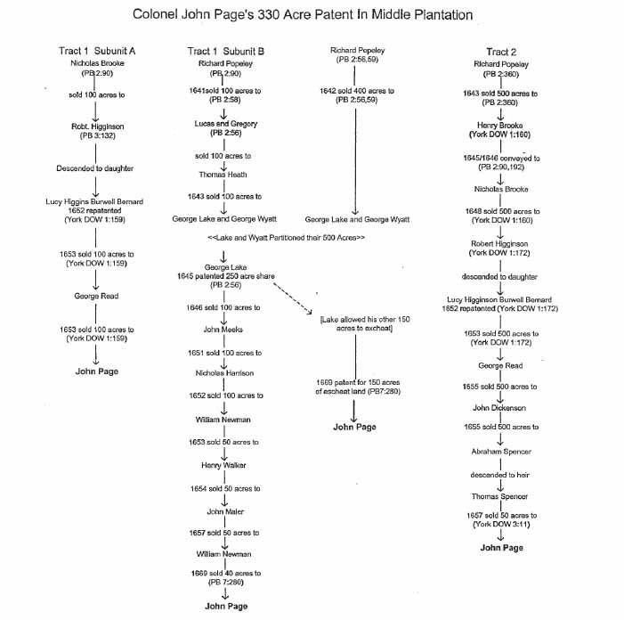 Colonel John Page's 330 Acre Patent in Middle Plantation
45
50 acres (Tract 2) from Thomas Spencer, who had inherited it from his father, Abraham Spencer (York County Deeds, Orders, Wills 1:160, 172; 3:11; Patent Book 2:90, 192, 360; 3:132).
Colonel John Page's 330 Acre Patent in Middle Plantation
45
50 acres (Tract 2) from Thomas Spencer, who had inherited it from his father, Abraham Spencer (York County Deeds, Orders, Wills 1:160, 172; 3:11; Patent Book 2:90, 192, 360; 3:132).
Tract 1 Subunit B, which lay along the east side of the palisade and adjoined Tract 1 Subunit A, originally was patented by Richard Popeley. Popeley on February 1, 1642 sold 100 acres (a plantation called the Middle House) to Thomas Gregory and Thomas Lucas, and on April 12, 1642, he conveyed 400 acres to George Lake and George Wyatt. Gregory and Lucas quickly deeded their 100 acre tract to Thomas Heath, who in 1643 sold it to George Lake and George Wyatt. Through this means, George Lake and George Wyatt came into possession of 500 acres of land that was located along the east side of the palisade. In 1645 Lake and Wyatt decided to partition their property and each man received 250 acres. The land George Lake was assigned abutted the southeast side of the palisade in the immediate vicinity of what became Williamsburg. As Lake received the 250 acres that formerly had belonged to Thomas Gregory and Thomas Lucas, his parcels were long, narrow and rectangular. On the other hand, George Wyatt's 250 acres, which was to the west of the property George Lake was allocated, abutted the east side of the palisade that paralleled College Creek and formed the eastern boundary line of the Rich Neck tract (Patent Book 2:54, 56, 55-59).
By 1669 approximately 180-190 acres of George Lake's 250 acres had become part of Colonel John Page's patent whereas the rest of Lake's land and all of George Wyatt's had become part of the Bray holdings. It appears to have been upon the Lake tract that Page built his home.29 The patent for 330 acres that Page was allocated on April 16, 1683, indicates that Tract 1 Subunit B was comprised of two parcels (40 acres and 150 acres), each of which had descended from George Lake's 250 acres. The Page patent indicates that in 1646 George Lake had sold 100 acres to John Meeks, who in 1651 had sold his land to Nicholas Harrison. Harrison assigned the 100 acres to William Newman in 1652. He, in turn, conveyed 50 acres to John Maler (Moler, Malen) in 1634, noting that. William Dyer was then leasing part of his land. In 1657 Maler deeded his 30 acres to William Newman, who in 1669 sold 10 acres to William Plumtree and 40 acres to John Page. Page in 1669 patented 150 acres of George Lake's land that had escheated to the Crown and combined it with the 40 acres of Lake land that he had bought from William Newman. In 1682 when Page had his land surveyed, it was found that he had 180 acres of George Lake's patent, not 190 (Patent Book 7:280-283; Nugent 1969-1979:II:261). This sequence of land transactions indicates that 230 of the 330 acres that Colonel John Page patented in 1653 (Tract 1 Subunit B and Tract 2) originally had belonged to Richard Popeley, whereas the residual 100 acres (Tract 1 Subunit A) had belonged to Nicholas Brooke.
On October 29, 1673, bricklayer John Bird of Surry County brought suit against Colonel John Page as the executor of his brother, Mathew Page. It was only three weeks later that John purchased a Jamestown lot from his widowed daughter, Mary Chiles, property that already contained improvements. At the time of the purchase, John Page was identified as a merchant and resident of Bruton Parish. From time to time he served 46 as an attorney and he also audited executors' accounts and arbitrated disputes (McIlwaine 1924:350, 358, 364, 370, 434, 441; Ambler MS 24).
During 1672 and 1674 John Page purchased three parcels of land (an aggregate of 163 acres "bounding on the old Pallizado at Middle Plantation") that straddled the New Kent (Richmond) road and abutted part of the acreage he already owned. On January 15, 1672, John bought from Henry Wyatt 50 acres that Wyatt had acquired from George Lake on August 4, 1661. Lake was quoted as indicating that he had obtained the parcel from Francis Peale, who had acquired it from William Bird and William Bray, who patented the land on February 8, 1639 (York County Deeds, Orders, Wills 5:1). On March 16, 1674, John Page purchased an adjoining 50 acres from George Bates, a carpenter, whose brother, John, had patented it on September 15, 1655, and then assigned it to George (York County Deeds, Orders, Wills 5:65).30 Finally, on May 25, 1674, John Page bought from John White II (the son and heir of patentee John White I) a 68 acre tract that abutted both of his 50 acre parcels. Reference was then made to a cherry tree "at a little slipe of land formerly belonging to Francis Peale" (a feature identified on Robert Beverley I's 1674 and 1678 plats) and the corner of Richard Guy's patent, a tract that extended eastward along the upper side of the old palisade (York County Deeds, Orders, Wills 5:65) (see the map "Middle Plantation 1699/1700" for the location of these parcels).31
Significantly, the boundaries of the 68 acres that Colonel John Page acquired from John White II in 1674 are shown on the plats Robert Beverley I made in 1674 and 1678. At that time, the 68 acre tract was attributed to Page. Beverley, when executing the 1674 plat quoted Thomas Ludwell as saying that the 330 acre tract he was conveying to Ballard were "part of a Greater divdt of Land now belonging to me Thomas Ludwell, Purchased from John White" (Beverley 1674) . Thus, Page's 68 acres and the 330 acre Ballard tract had their origin in land previously owned by John White I. In October 1679, John and Alice Page gave their aggregate of 168 acres "all lying together" to their son, Francis, who by 1692 had begun erecting some brick buildings upon the property: a house, a barn, a malthouse, and perhaps some other structures (see ahead). The Page couple also gave their son, Francis, eight slaves (old Peter, Moll, Jack, Joane, Sampson, Mary, James and Jeffrey) (York County Deeds, Orders, Wills 6:128) (see ahead). This transaction preceded Francis Page's marriage to Mary Digges, which occurred in 1682 (see chart entitled "Page Family Genealogy").
While the colony was in the throes of Bacon's Rebellion, Colonel John Page, a councillor, remained loyal to Governor William Berkeley. As a result, the rebel leader Nathaniel Bacon proclaimed him a traitor. Later, Page's home was plundered and his wife, Alice, was one of the women Bacon's men seized and used as a human shield while building a defensive trench at the entrance to Jamestown Island. Although Page in August 1676 signed the Oath that Bacon presented for his signature, afterward he asked for a pardon, which was granted. John Page was listed along those who had suffered financial losses that were attributable to Bacon's Rebellion (Force 1963:I:9:8; Wiseman Book of Record [1677]; Aspinall et al. 1871:172; C.O. 5/1371 ff 171-178; York County Deeds, Orders, Wills 6:207, 209) .
47During the mid-1670s John Page functioned as the factor of London merchant and alderman John Jeffreys, a major investor in the Royal African Company, which was heavily involved in the slave trade. In September 1676, when Bacon's men put Jamestown to the torch, a substantial quantity of Jeffreys' wine was destroyed that was stored in Page's cellars. Afterward, Pace filed a claim on Jeffreys' behalf (C.O. 1/12 f 115; 1/41 f 218; 5/1344 ff 200-203; Sainsbury 1964:10:167; Withington 1980:51).
In mid-February 1677 the assembly authorized John Page to find land at Middle Plantation that the king's soldiers could use for growing corn. He also was to oversee the construction of some buildings that were to house the king's troops and munitions, the structures William Sherwood and Thomas Rabley erected on their acreage in Middle Plantation. In 1677 a chest entrusted to the care of the king's deputy paymaster was to be "deposited at Mr Pages' house in the Middle Plantation, as being in the main guard of soldiers" (Neville 1976:331) .
In 1678 John Page donated the land upon which Bruton Parish Church was built. Three years later he was named to the Governor's Council and in 1682, it was decided that the colony's military stores (described as "Armes, partisans, Halberts, Drums, Swords, pikes and amunition, as alsoe what is in… appertaining to his Majesties stores") should be "carted unto house of him ye said Coll. John Page att Middle Plantation," where they were to be secured.32 Page also was supposed to see that "ye great Gunns and Shott" that belonged to the king's troops were "lodged in ye Guard house or other such convenient place." Finally, in May 1684, the king's guard at Middle Plantation was dismissed (McIlwaine 1905-1915:1660-1693:71-73; 1925-1945:I:25, 499).
By 1686 Colonel John Page had begun serving as the colony's escheator and in l690 he was ordered to inventory the military stores in the fort at Jamestown. When Page died in 1692 he left a widow, Alice, and four grown children: Francis, Mathew, Mary and Elizabeth. Alice inherited life-rights to her late husband's property in Middle Plantation and the New Kent County plantation called Mahixon, and her son, Francis, was named as reversionary heir. Colonel John Page was interred at Bruton Parish Church. His widow, Alice, seemingly continued to occupy the family home, which she shared with her orphaned granddaughter, Elizabeth, the child of Francis and Mary Digges Page. Alice died in 1698 and was buried between her husband and son Francis (McIlwaine 1905-1915:1660-1693:71-72; 1925-1945:I:25, 117; Nugent 1969-1979:II:261; Meade 1992:I:146; Stanard 1965:41; Palmer 1968:I:21; Ambler MS 37; York County Deeds, Orders, Wills 3:103: 9:127-128; 11:85-86; C.O. 5/1358 f 77; Meyer et al. 1987:410).
In 1699 when Williamsburg was laid out and surveyed into lots, much of Colonel John Page's 330 acre patent lay within the new city's limits. By that date, Page and his wife, Alice, were dead, as was their son, Francis, who inherited their land at Middle Plantation. Therefore, the Pages' Middle Plantation property had descended to 17-year-old Elizabeth Page. In 1705 the assembly decided to tear down four old houses and an oven that were attributed to "Mr. John Page" and were situated within the right-of-way of the newly laid out Duke of Gloucester Street (McIlwaine 1905-1915:1702-1712:55, 69). It is probable that those "old" structures were built by Colonel John Page, but in 1705 were in the hands of John Page of Gloucester County, the widower of Francis
48
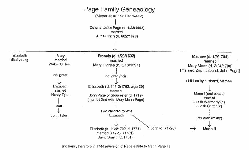 Page Family Genealogy
49
Page's daughter, Elizabeth, who died in February 1702, leaving heirs to the property she had inherited from her father and paternal. grandfather (Meyer et al. 1987:412) (see ahead).
Page Family Genealogy
49
Page's daughter, Elizabeth, who died in February 1702, leaving heirs to the property she had inherited from her father and paternal. grandfather (Meyer et al. 1987:412) (see ahead).
Francis Page (son of Colonel John and Alice Page)
Francis Page, the son of John and Alice Lukin Page, was born in 1657. In 1682 he married Mary Digges of York County, with whom he produced an only child, Elizabeth. In 1680 Francis served as a York County justice of the peace and a member of Bruton Parish's vestry. He was a burgess from 1684 to 1691 and from 1686 to 1691 was clerk of the assembly. On May 12, 1684, he was named to the committee assigned the task of rebuilding the statehouse at Jamestown (Meyer et al. 1987:410-411; McIlwaine 1905-1915:1660-1693:220).
As previously noted, in October 1679, John and Alice Page gave their son, Francis, eight slaves and a 168 acre tract of land at Middle Plantation. That parcel, which abutted south upon the New Kent (Richmond) road and what became the original campus of the College of William and Mary, was comprised of three subunits that Colonel John Page had purchased from Henry Wyatt, George Bates, and John White II between 1672 and 1674 (York County Deeds, Orders, Wills 5:1, 65; 6:128). The 68 acres John Page bought from John White II are shown on plats Robert Beverley I made in 1674 and 1678 (see the chart entitled "The Origin and Descent of Francis Page's Middle Plantation land").
In 1687, when Colonel John Page made his will, he left life-rights in his Middle Plantation property to his widow, Alice, but named son Francis as reversionary heir. Within months of John Page's death, which occurred around February 1692, Francis Page, whose wife, Mary had died in January 1691, became mortally ill. When preparing his will, Francis named his daughter, Elizabeth, as his sole heir. He entrusted the child to the care of his widowed mother, Alice Page, and asked his brother-in-law, Dudley Digges, to see that young Elizabeth was educated properly. Francis Page designated his mother as overseer of the property his daughter stood to inherit and stated that if Elizabeth failed to survive and produce heirs, his brother, Mathew, was to inherit his real and personal estate. Francis instructed his executors to see that his "brick mault house and brick barne with all other my houses at Middle Plantation be forthwith finished" and kept in good repair, and "leased by my Executors till my sd daughter come to the age of 1 and 20." The real estate to which he referred was the 168 acre tract he had been given by his parents. By May 1692 Francis was dead. He was buried in the yard at Bruton Parish Church, near the graves of his wife and father (York County Deeds, Orders, Wills 6:128; 9:99, 126-127; Meyer et al. 1987:412; Meade 1992:146).
In August 1695 Poynes Weldon was licensed to keep an ordinary "at the house lately belonging to Fra. Page and now in the possession of Captain Mathew Page, and where Tho. Taylor formerly dwelt" (York County Deeds, Orders; Wills 18:189)
.33 This statement indicates that Francis's house went through a succession of occupants while
50
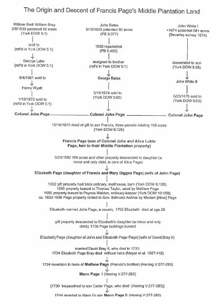 The Origin and Descent of Francis page's Middle Plantation Land
51
it was entrusted to the management of his executors, one of whom was his mother (Goodwin 1934,:48).
The Origin and Descent of Francis page's Middle Plantation Land
51
it was entrusted to the management of his executors, one of whom was his mother (Goodwin 1934,:48).
During the mid-to-late 1690s Governor Edmund Andros, who was governor from September 1692 to December 1698, resided at Middle Plantation in a house that was close to the College of William and Mary. As college officials were anxious for the Rev. James Blair to open its grammar school, and as "there being no fit house on the place [Middle Plantation] but one where he the said Blair the schoolmaster & the scholars could live, and [as] that house, [was] being at present in the Governr's possession," Blair arranged to rent the dwelling as soon as Andros vacated it. Although Governor Andros moved from Middle Plantation to a house near Jamestown, he retained the Page dwelling for several more months and left one of his servants there, an elderly man named Mr. Wells. Wells, who was seriously ill, eventually moved elsewhere, but Andros refused to relinquish the Page house until he had to, seemingly just to spite Blair. Even then, Andros departed only on account "of h[i]s own conveniency & Some differences with Madam Page, his Landlady" (Stanard 1965:17; McGhan 1993:873; Goodwin 1954:48) .
The location of the dwelling Governor Andros was renting from "Madam Page" (probably the late Francis Page's mother, Alice, as his daughter, Elizabeth, was underage) is uncertain. However, the structure's proximity to the college and Mrs. Page's involvement as landlady raise the possibility that it stood upon the late Francis Page's property, for which she was responsible up until the time of her death in June 1698: the 168 acre tract near College Corner that was on the upper side of the New Kent (Richmond) Road and contained at least three brick buildings.
In December 1705, when Mungo Ingles, schoolmaster at the college, wrote to Francis Nicholson, he quoted Robert Beverley II as saying that "He yt [that] burnt Mr. Pages houses burnt ye College - & yt your Excy: burnt. Mr Pages houses" (Goodwin 1954:108-109) . This statement raises the possibility that one or more of the late Francis Page's houses near the college had been destroyed, seemingly by an arsonist. Ingles, in a second letter he dispatched to Nicholson in February 1706, added that no one knew the cause of the fire at the college, but that the man reporting it had testified that "he saw 3 Men cloathed like Getts run from ye College across ye New Kent [Richmond] road."34 Ingles added that "Beverley and some others of the Party kept Drinking & Ranting & carousing all that night after ye fire & when ye Stonecutter went to save ye Smokehouse from being burnt, One o them curs'd it, & bid him let it go with ye College. Another of them… was heard to say that if some Thunderbolt or lightening should destroy ye Capitol, they might have some hopes of having ye Seat of Governmt in James Town" (Goodwin 1954:111) . Thus, the idea of relocating the capital from Jamestown to Williamsburg was an emotionally charged issue that may have contributed to the destruction of Francis Page's buildings near the college.
Elizabeth Page Page (the daughter of Francis Page)
Elizabeth, the orphaned daughter of Francis and Mary Digges Page, married John Page, one of her father's cousins.35 Although she died on November 12, 1702, at the age of 20, she had lived long enough to produce two children: a son named John, born in ca. 1699, and a daughter named Elizabeth, who was born on November 4, 1702 (Meyer et al. 1987:412).36 In January 1700 when William Hansford sold 300 acres of York County land to James Whaley , a tract just outside the city limits and abutting the main road to Yorktown, reference was made to the property's adjoining that of John Page (Elizabeth Page Page's husband), William Dyer, Thomas Bray (I) and Madam (Angelica) Bray (York County Deeds, Administrations, Bonds 1:259-260). The location of the property Whaley purchased is shown on the map entitled "Middle Plantation, 1699-1700."
In April 1705, the assembly recommended that "the old house belonging to Mr. John Page standing in the middle of Gloucester Street be pulled downe that the prospect of the Street between the Capitol and the Colledge may be clear" (McIlwaine 1905-1915:1702-1712:55). Later, the burgesses agreed to pay Page three pounds for "the old houses which stand on Gloucester Street." They were to be razed by the men building the capitol, who were to "lay the Bricks out of the Street on the Lott of the Said John Page." The structures being dismantled were described as "four old Houses and Oven" (McIlwaine 1905-1915:1702-1712:69). Although the "old Houses" probably had been erected by Colonel John Page, who died in 1692, the John Page to whom a lot was attributed in 1705 would have been Elizabeth Page Page's widower.
Elizabeth Page Bray (the granddaughter of Francis Page)
Elizabeth, the sole surviving heir of her maternal grandfather, Francis Page, was born on November 4, 1702, eight days before her mother died. She stood to inherit Francis's property in Middle Plantation, which included the brick dwelling constructed by her great-grandfather, Colonel John Page, and the 168 acres he had given his son, Francis, in 1679. In 1705 Elizabeth's father, John Page of Gloucester, who was widowed on November 12, 1702, married his late wife's aunt, Mary Mann, whose husband, Mathew Page, had died in January 1704.37 Through this means, two branches of the Page family unified their fortunes. Elizabeth's father, John Page, died in 1719 and in March 1728 the assembly decided that the money owed the late John Page (presumably Colonel John Page) "for land on which the city is built" was to be paid to Mann Page I for the use of Elizabeth Page (McIlwaine 1918:751; Meyer et al. 1987:412).38 Mann Page I, who was 53 Elizabeth's first cousin and the late Mathew Page's son, was then serving as her legal representative, an indication that she was unmarried. Elizabeth already had sold Mann Page I a 200 acre tract on the east side of Williamsburg, acreage that she had inherited from her father (Waller 1743).
Sometime after March 1728, Elizabeth Page married David Bray II, whose family (like Elizabeth's) had lived in Middle Plantation for at least three generations (Meyer et al. 1987:412) Elizabeth and David Bray II failed to produce living heirs and on June 4, 1731, when he made his will, he bequeathed all of the real and personal property in his possession to Sir John Randolph of Williamsburg. Thus, David Bray II overlooked or purposefully ignored the fact that his late father, David I, and his late grandfather, James I, had named Thomas Bray II (the son of James Bray II), as their reversionary heir, if David II were to die childless. In May 1732, after David Bray II's death, his relatives asked the House of Burgesses to partition the property he had inherited f rom his father and grandfather, which had descended to him through his late uncle, Thomas Bray (Winfree 1971: 381-383).
When the widowed and childless Elizabeth Page Bray died in 1734, the land she had inherited from her grandfather, Francis, which had descended to her late mother, reverted to the descendants of her great-uncle, Mathew Page. Through this means, Mann Page I, the son of Mathew and Mary Mann Page, stood to inherit the Page holdings in Middle Plantation. In January 1730, when Mann Page I made his will, he left his legal interest "in lands late of my Uncle Mr. Francis Page and which are now in the possession of Mr. David Bray [II] to my Son Carter." David Bray II and wife Elizabeth Page may have occupied the Page homeplace near Williamsburg, instead of one of the properties he inherited.39 In September 1744 Mann Page I's son and heir, Mann II, received the assembly's permission to sell off some of the entailed property he had inherited from his late father. Included was the Page land that Mann Page I had left to his son, Carter Page, who had died without inheritors, leaving Mann II as residual heir (Meyer et al. 1987:412; Hening 1809-1823:V:279-281; Stanard 1924:41). In December 1743 Mann Page II had made arrangements to sell Benjamin Waller 745 acres that abutted the city of Williamsburg on three sides (Waller 1743).
Archaeological Features Associated with Francis Page's 168 Acres
Robert Beverley I's 1674 and 1678 plats indicate that John Page had acreage along the upper side of the New Kent (Richmond) road near its intersection with the road to Jamestown. In 1679, John and Alice Page executed a deed of gift, conveying to their son, Francis, 168 acres of land in Middle Plantation that. was comprised of three pieces of property: a 68 acre tract shown on the Beverley plat; 50 acres that abutted that parcel's 54 northerly boundary; and 50 acres that lay to the east. All three parcels were contiguous. In 1692, when Francis Page made his will, he instructed his executors to see that his "brick mault house and brick barne with all other my houses at Middle Plantation be forthwith finished," kept in good repair, and placed in the hands of tenants. In 1695 Poynes Weldon kept an ordinary at Middle Plantation; in York County, "at the house lately belonging to Fra. Page and now in possession of Capt. Mathew Page and where Tho. Taylor formerly dwelt." As it is likely that an ordinary would have been situated at a site convenient to the traveling public, Page's ordinary probably was located upon the 68 acre parcel, which abutted south and southwest upon the New Kent road. If so, it would have been somewhere between College Corner and the Williamsburg Shopping Center, on the upper side of Richmond Road. During the late 1690s, while Governor Edmund Andros was renting a dwelling near the college from Madam Page (probably Alice Page, who was then responsible for the property of her son's orphaned daughter, Elizabeth), the structure burned. In 1705 when the college caught fire, some people attributed the blaze to the same people who allegedly had burned "Pages houses."
Archaeological Features Associated with Colonel John Page's Plantation
Archaeological remains of the domestic complex constructed by Colonel John Page in ca. 1662 and occupied by him and is wife, Alice, have been identified on the grounds of the Bruton Heights School, where there also may be evidence of the military stores that John took there in 1682. Alice Page, upon being widowed in 1692, probably stayed on in the family home until her death in 1698, for she had life-rights in the property. At Alice's death, the plantation reverted to the Page couple's granddaughter, Elizabeth, the daughter and sole heir of their son, Francis Page. Elizabeth, who wed her cousin, John Page of Gloucester County, died in November 1702 at age 20. Although her life was abbreviated, she lived long enough to produce two children: a son named John who was born in ca. 1697 and a daughter named Elizabeth, who was born in 1702. The widowed John Page remarried, taking as his wife Mary Mann Page, the widow of Mathew Page. Although the couple resided in Gloucester, they may have made occasional use of the property that had belonged to John's late wife. John and Elizabeth Page Page's son, John, may have occupied the homeplace until the time of his death in 1727. When young Elizabeth Page matured, she married David Bray II, whose family had lived in Middle Plantation for at least three generations. David and Elizabeth Page may have occupied the domestic complex she had inherited from her great-grandfather, for when David II made his will in 1731, he left all of this real and personal property to John Randolph. As the land David Bray II had inherited from his family was partitioned and divided between Randolph and the Bray heirs in May 1732, while Elizabeth was still alive, she probably was residing upon the property she had inherited from her forebears. Elizabeth died in 1734.
Archaeological Features Near the Wythe House
Archaeological features dating to the seventeenth century and discovered near the Wythe House are located within the boundaries of Tract 1 Subunit B, part of Colonel John Page's patent for 280 acres. Prior to Page's 1669 acquisition of the property, it was 55 owned successively by Richard Popeley, George Lake and George Wyatt, George Lake, John Meeks, Nicholas Harrison, William Newman, Henry Walker, John Maler and William Newman (see "Colonel John Page's 330 Acre Patent in Middle Plantation").
Archaeological Features in Duke of Gloucester Street
On April 27, 1705, the assembly recommended that "the old house belonging to Mr. John Page standing in the middle of Gloucester Street be pulled downe that the prospect of the Street between the Capitol and the Colledge may be clear" (McIlwaine 1905-1915:1702-1712:55) . The burgesses, at their May 5th session, decided to pay Page three pounds for "the old houses which stand on Gloucester Street." Page's buildings were to be razed by the workers who were involved in building the capitol. They were supposed to "Lay the Bricks out of the Street on the Lott of the Said John Page." The structures being dismantled were described as "four old Houses and Oven" (McIlwaine 1905-1915:1702-1712:69) . These buildings would have been on the property that had belonged to Colonel John Page (deceased in 1692) and descended through his son, Francis (also deceased in 1692), to his granddaughter, Elizabeth, who prior to 1697 wed her cousin John Page, Robert Page's son. They were located within Tract 1 Subunit B, land that Colonel John Page patented in 1669.
Publicly Owned Buildings on the Capitol Grounds
In May 1700, the governor's council decided that some of the ordnance, shot and materiel at Jamestown should be taken to "the place designed for building the Capitoll." Whether these military stores were to be kept out in the open or within a building is unclear. Sometime prior to 1704, however, there were "country houses" (or publicly owned buildings) on the grounds of what became the capitol.
While the capitol was under construction, there were two so-called "country houses" (i.e., buildings erected at public expense) on the capitol grounds, plus a third that was being used by the workmen in the preparation of lime. In 1704 the assembly acquired from Henry Cary the three houses and the land upon which they stood and told him that the lime house had to be removed from the capitol grounds (Winfree 1971:33). Thus, Cary appears to have owned part of the acreage designated for inclusion in the grounds surrounding the capitol.40 In 1705, George Burton, a painter who was called upon to testify about the fire at the college, said that "he lay in the Countrys houses at ye Capitol on ye 29th of Octr last at night. That after he had heard ye Capitol Clock strike Eleven one Wm. Craig cryed out the College was on fire, Whereupon the Deponent got out of bed, and seeing the light he ran out to ye Street wch frontes ye College & saw ye fire." Captain Thomas Barber, who also was in bed "in one of ye Country's houses near the Capitol," was awakened by Miles Cary, who shouted that the college was on fire (Bruce 1899:272-277).
THE DYER FAMILY'S LANDHOLDINGS
William Dyer
The name of William Dyer, a wheelwright, first appeared in York County records in 1672, at which time he agreed to make a pair of cart-wheels for Edward Sanderson. By 1675 Dyer owned a 50 acre tract in York County, southeast of what became later became the capitol grounds, land he had bought from Nathaniel Malen. He also purchased an additional 50 acres from Jane Ubank. In August 1680 William Dyer was censured for selling liquor without a license and in October 1685 he was summoned to court for failing to attend church. His wife, Mary, also ran afoul of the law in 1685 for she concealed the murder of a child. In 1687 he mortgaged half of his 100 acre tract to Daniel Parke, for whom he agreed to serve as a wheelwright for six months, making 30 pair of cart wheels. By early 1698 William Dyer was dead. His 50 acre tract abutting the road to Yorktown was used as a reference point in 1700, and again in 1704, when some neighboring property was patented (York County Deeds, Orders, Wills 4:372; 5:53; 6:238; 7:2, 112, 350; 11:21; Deeds, Administrations, Bonds 1:259-260).
Henry Dyer
After William Dyer's demise, his property descended to his son, Henry, who also was a wheelwright. He sold the 50 acres and tenements "near Williamsburg" that he had inherited from his father to James Morris, a carpenter (York County Deeds, Orders, Wills 11:243-244; Deeds, Administrations, Bonds 2:337-338). The Dyer property is shown upon the map entitled "Middle Plantation 1699/1700."
BIBLIOGRAPHY
- 1636-1809
- Library of Congress, Washington, D. C. Transcripts and microfilm, Rockefeller Library, Colonial Williamsburg Foundation, Williamsburg.
- 1967
- Narratives of the Insurrections, 1665-1690. Charles Scribner's Sons, New York.
- 1677
- Articles of peace between the most serene and mighty Prince Charles II … and several Indian Kings and Queens, &c. concluded the 29th day of May 1577. In B.P.R.O.: Colonial Office 1/40 ff 202-203.
- 1782
- Plan de la Ville et environs de Williamsburg en Virginie. Rockefeller Library, Colonial Williamsburg Foundation, Williamsburg.
- 1871
- Collections of the Massachusetts Historical Society. (Fourth Series) 9:1-164.
- 1674
- Surveyed ye last of Novembr 1674 Att the request of Mr Secretary Ludwell. Rockefeller Library, Colonial Williamsburg Foundation, Williamsburg.
- 1678
- A Mapp of land Surveyed at the Instance of Mr. Sec. Ludwell and Coll. Thomas Ballard, Mr. John Page being also present at the perfecting the survey, June 16, 1678. Rockefeller Library, Colonial Williamsburg Foundation, Williamsburg.
- 1947
- History of the Present State of Virginia (1705). L.B. Wright, ed. University of North Carolina Press, Chapel Hill.
- 1699
- Draft of the City of Williamsburg and Queen Mary's Port and Princess Anne's Port in Virginia. Library of Congress, Washington, D.C.
- 1705
- Additional Manuscripts. Microfilm on file at Rockefeller Library, Colonial Williamsburg Foundation, Williamsburg.
- 1895
- Instructions to Berkeley, 1642. Virginia Magazine of History and Biography, 2: 281-288.
- 1899
- Vindication of Sir William Berkeley. Virginia Magazine of History and Biography 6:139-144.
- 1941
- The Secret Diary of William Byrd of Westover 1709-1712. Louis B. Wright and Marion Tinling, eds. The Dietz Press Inc., Richmond.
- 1655-1846
- Deeds, Wills, Order Books. Charles City County Courthouse, Charles City, and Library of Virginia, Richmond. 58
- 1980
- English Estates of American Colonists. Genealogical Publishing Company, Baltimore.
- 1607-1846
- Colonial Office Papers, British Public Records Office, Kew, England. Survey Reports and Microfilms Rockefeller Library, Colonial Williamsburg Foundation, Williamsburg.
- 1853
- Voyages from Holland to America, Led 1632, to 1644 by David Peterson Devries, Henry C. Murphy, trans. New York: no publisher listed.
- 1590-1790
- Ferrar Papers, Pepys Library, Magdalen College, Cambridge University, Cambridge, England. Microfilms, Rockefeller Library, Colonial Williamsburg Foundation, Williamsburg.
- 1963
- Tracts and Other Papers, Relating to the Origin, Settlement and Progress of the Colonies in North America. 4 vols. Peter Smith, Gloucester, Mass.
- 1755
- A Map of the Most Inhabited Part of Virginia. Virginia Department of Historic Resources, Richmond.
- 1770
- [Plat annexed to a certain deed from Corbin and others… Philip Ludwell, dec., to Paradise, 1770]. Rockefeller Library, Colonial Williamsburg Foundation, Williamsburg.
- 1927
- The Colonial Church in Virginia. Morehouse Publishing Company, Milwaukee.
- 1954
- Historical Notes: The College of William and Mary. Rockefeller Library, Colonial Williamsburg Foundation, Williamsburg.
- 1972
- Kingsmill Plantation. Rockefeller Library, Colonial Williamsburg Foundation, Williamsburg.
- 1957
- A True Discourse of the Present Estate of Virginia and the Success of the Affaires There till the 18th of June 1614. Virginia State Library, Richmond.
- 1940
- The Present State of Virginia and the College [1697] by Henry Hartwell, James Blair and Edward Chilton. Princeton University, Princeton.
- 1809-1823
- The Statutes At Large: Being a Collection of All the Laws of Virginia. 13 vols. Samuel Pleasants, Richmond. Reprinted 1967, 1969. 59
- 1916
- Report of the Journey of Francis Louis Michel. Virginia Magazine of History and Biography 24:1-43, 113-141, 275-288.
- 1980
- Original Lists of Persons of Quality, 1600-1700. Genealogical Publishing Company, Baltimore.
- 1778
- The Virginia Gazette, November 27, 1778. Photostat on file at Rockefeller Library, Colonial Williamsburg Foundation.
- 1645
- Letter to Sir William and Sir John Berkeley, February 27, 1645. Clarendon Manuscript #24 ff 48-51. Bodleian Library, Oxford University, Oxford.
- 1906-1935
- Records of the Virginia Company of London. 4 vols. Government Printing Office, Washington.
- 1989
- So Good A Design: The Colonial Campus of the College of William and Mary: Its History, Background and Legacy. The College of William and Mary, Williamsburg.
- 1978
- Rosewell: Garland of Virginia. Gloucester County Historical Committee, Gloucester.
- 1978
- The General Assembly of Virginia, July 30, 1619-January 1, 1978, A Bicentennial Register of Members. Virginia State Library Board, Richmond.
- 1666-1675
- Deeds and Wills. Library of Virginia,. Richmond.
- 1698/99
- February 4, 1698/99, deed from Philip Ludwell [I] to James Blair. Virginia Historical Society, Richmond.
- 1707
- August 5, 1707, lease from Philip Ludwell [II] to James Blair and his wife, Sarah. Virginia Historical Society, Richmond.
- 1993
- Virginia Will Records. Genealogical Publishing Company, Baltimore.
- 1918
- Legislative Journals of the Council of Colonial Virginia. 3 vols. Virginia State Library, Richmond. Reprinted 1979.
- 1925-1945
- Executive Journals of the Council of Colonial Virginia. 5 vols. Virginia State Library, Richmond. 60
- 1924
- Minutes of Council and General Court of Colonial Virginia. The Library Board, Richmond. Reprinted 1934, 1979.
- 1905-1915
- Journals of the House of Burgesses, 1619-1776. 13 Vols. Virginia State Library, Richmond.
- 1992
- Old Churches, Ministers and Families of Virginia. 2 vols. Genealogical Publishing Company, Baltimore. Reprinted 1992.
- 1987
- Adventurers of Purse and Person, 1607-1624/25. Dietz Press, Richmond.
- 1996
- Virginia Carolorum: The Colony Under the Rule of Charles the 1st and 2nd. J. Munsell's Sons, Albany New York.
- 1976
- Bacon's Rebellion, Abstracts of Materials in the Colonial Records Project. The Jamestown Foundation, Williamsburg.
- 1969-1979
- Cavaliers and Pioneers: Abstracts of Virginia Land Patents and Grants. 3 vols. Dietz Press, Richmond and Genealogical: Publishing Company, Baltimore.
- 1968
- Calendar of Virginia State Papers. 11 vols. Kraus Reprint, New York.
- 1982
- Virginia Land Records. Genealogical Publishing Company, Baltimore.
- 1623-1762
- Virginia Land Office Patent Books. Microfilm on file at Library of Virginia, Richmond, and Rockefeller Library, Colonial Williamsburg Foundation, Williamsburg.
- 1969
- Historical Collections Relating to the American Colonial Church. Vol. I, Virginia. AMS Press, New York.
- 1605-1693
- Principal Probate Register, British Public Records Office, Kew, England. Survey Reports and photocopies, Rockefeller Library, Colonial Williamsburg Foundation, Williamsburg.
- 1676-1680
- Privy Council, British Public Records Office, Kew, England. Survey Reports and photocopies, Rockefeller Library, Colonial Williamsburg Foundation, Williamsburg.
- 1678-1679
- Public Record Office, British Public Record Office, Kew, England. Survey Reports and photocopies, Rockefeller Library, Colonial Williamsburg Foundation, Williamsburg. 61
- 1980
- Biographical Directory of American Colonial and Revolutionary Governors, 1607-1789. Meckler Books, Westport, Conn.
- 1972
- Tidewater Towns: City Planning in Colonial Maryland. University of Virginia Press, Charlottesville.
- 1957
- A True Relation of the State of Virginia, Lefte by Sir Thomas Dale Knight in May Last 1616. University Press of Virginia, Charlottesville.
- 1964
- Calendar of State Papers, Colonial Series, America and the West Indies. 22 Vols. Kraus Reprint, Vaduz.
- 1643
- Survey of Richard Kemp's Land. Rockefeller Library, Colonial Williamsburg Foundation, Williamsburg.
- 1983
- The Virginia Militia in the Seventeenth Century. Louisiana State University Press, Baton Rouge.
- 1942
- John Paradise and Lucy Ludwell of London and Williamsburg. The Dietz Press, Inc., Richmond.
- 1970
- The Statutes At Large of Virginia. 3 vols. AMS Press, New York.
- 1693
- November 8, 1693, deed from William Sherwood to Daniel Parke, 17 acres at Middle Plantation. Rockefeller Library, Colonial Williamsburg Foundation, Williamsburg.
- 1957
- The Quitrents of Virginia. Privately published, Gloucester County, Virginia.
- 1907
- Virginia Gleanings in England. Virginia Magazine of History and Biography 14:419-426.
- 1915
- Acts, Orders and Resolutions of the General Assembly Virginia at Sessions of March 1643-1644. Virginia Magazine of History and Biography 23:229-239, 250-254.
- 1933
- Lower Norfolk County Records. Virginia Magazine of History and Biography 41:19-61.
- 1965
- Colonial Virginia Register. Genealogical Publishing Company, Baltimore.
- 1959
- Custis Square Historical Report, Block 4 Lots 1-8. Rockefeller Library, Colonial Williamsburg Foundation, Williamsburg. 62
- 1968
- A Record of the Thomas Bray Family, 1658-ca. 1800. Rockefeller Library, Colonial Williamsburg Foundation, Williamsburg.
- 1900
- The Cradle of the Republic. Whittet and Shepperson, Richmond.
- 1906
- The Cradle of the Republic. The Hermitage Press, Inc., Richmond.
- 1743
- December 13, 1743, deed from Mann Page II. Waller Collection, Rockefeller Library, Colonial Williamsburg Foundation, Williamsburg.
- 1749
- William Waller's Subdivision. Rockefeller Library, Colonial Williamsburg Foundation, Williamsburg.
- 1922
- The Planters of Colonial Virginia. Princeton University Press, Princeton.
- 1653-1671
- Deeds and Wills 1 [1653-1671]; Deeds, Patents Etc. 1665-1677. Microfilms on file at the Library of Virginia, Richmond.
- 1768-1769
- Tax Lists. Rockefeller Library, Colonial Williamsburg Foundation, Williamsburg.
- 1971
- The Laws of Virginia Being a Supplement to Hening's The Statutes At Large, 1700-1750. Virginia State Library, Richmond.
- 1676-1677
- Samuel Wisenian's Book of Record. Microfilm, Rockefeller Library, Colonial Williamsburg Foundation, Williamsburg.
- 1980
- Virginia Gleanings in England. Genealogical Publishing Company, Baltimore.
- 1633-1800
- Deeds, Wills, Inventories, Orders. York County Courthouse, Yorktown, and Library of Virginia, Richmond. Microfilms on file at Rockefeller Library, Colonial Williamsburg Foundation, Williamsburg.